Enhaut, Pennsylvania facts for kids
Quick facts for kids
Enhaut, Pennsylvania
|
|
|---|---|

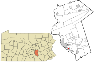
Location in Dauphin County and state of Pennsylvania.
|
|
| Country | United States |
| State | Pennsylvania |
| County | Dauphin |
| Township | Swatara |
| Area | |
| • Total | 0.23 sq mi (0.60 km2) |
| • Land | 0.23 sq mi (0.60 km2) |
| • Water | 0.00 sq mi (0.00 km2) |
| Elevation | 490 ft (150 m) |
| Population
(2020)
|
|
| • Total | 1,022 |
| • Density | 4,424.24/sq mi (1,711.05/km2) |
| Time zone | UTC-5 (Eastern (EST)) |
| • Summer (DST) | UTC-4 (EDT) |
| ZIP code |
17113
|
| Area code(s) | 717 |
| FIPS code | 42-23704 |
| GNIS feature ID | 1174268 |
Enhaut is a small community in Pennsylvania, United States. It is not a city or a town with its own government. Instead, it is an unincorporated community. This means it is part of a larger area called Swatara Township. Enhaut is also a census-designated place, or CDP. This is a special area that the government uses to count people for the census.
Enhaut used to be part of a bigger CDP called Bressler-Enhaut-Oberlin. But for the 2010 census, it became its own separate CDP. In 2010, about 1,007 people lived in Enhaut.
Where is Enhaut Located?
Enhaut is in Dauphin County, Pennsylvania. It is surrounded by other communities. To the southwest, you will find the borough of Steelton. To the southeast is Bressler. To the northeast, you will find Oberlin. Enhaut is about 4 miles (6 kilometers) southeast of Harrisburg. Harrisburg is the capital city of Pennsylvania.
Who Lives in Enhaut?
This section talks about the people who live in Enhaut. It is called demographics. The United States government counts everyone in the country every ten years. This count is called the census.
| Historical population | |||
|---|---|---|---|
| Census | Pop. | %± | |
| 2020 | 1,022 | — | |
| U.S. Decennial Census | |||
In the 2020 census, 1,022 people lived in Enhaut. This number helps us understand how the community is growing or changing.
See also

- In Spanish: Enhaut para niños

