Erongo Region facts for kids
Quick facts for kids
Erongo Region
|
|
|---|---|
|
Region
|
|

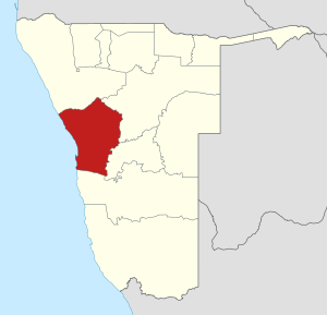
Location of the Erongo Region in Namibia
|
|
| Country | Namibia |
| Capital | Swakopmund |
| Area | |
| • Total | 63,539 km2 (24,533 sq mi) |
| Population
(2011)
|
|
| • Total | 150,809 |
| • Density | 2.373487/km2 (6.14730/sq mi) |
| Time zone | UTC+2 (CAT) |
The Erongo Region is one of the 14 main areas, called regions, in the country of Namibia. It is located on the western coast of Namibia. The capital city of this region is Swakopmund.
The region gets its name from Mount Erongo, a famous mountain in the area. Erongo is known for its beautiful desert landscapes and its connection to the Atlantic Ocean.
Contents
Leadership in Erongo
The Erongo Region has a leader called a Governor. The Governor helps to manage the region and make decisions for the people living there.
The Governor's Role
The Governor works to improve the lives of the people in the Erongo Region. They oversee local government and help with development projects.
Current Governor
As of 2020, Neville Andre Itope became the Governor of the Erongo Region. He is responsible for leading the region.
Electoral Areas
The Erongo Region is divided into smaller areas called electoral constituencies. These areas are important because people vote for their representatives in these constituencies.
Constituencies in Erongo
There are seven main electoral constituencies in the Erongo Region. Each one helps to make sure that different parts of the region have a voice in government.
- Arandis
- Dâures (This area used to be known as Brandberg Constituency)
- Karibib
- Omaruru
- Swakopmund
- Walvis Bay Rural
- Walvis Bay Urban
See also
 In Spanish: Región de Erongo para niños
 | Janet Taylor Pickett |
 | Synthia Saint James |
 | Howardena Pindell |
 | Faith Ringgold |

