Fürstenfeldbruck Rural District facts for kids
Quick facts for kids
Fürstenfeldbruck
|
|
|---|---|
 |
|
| Country | |
| State | Bavaria |
| Adm. region | Oberbayern |
| Region | Munich |
| Capital | Fürstenfeldbruck |
| Area | |
| • Total | 435 km2 (168 sq mi) |
| Population
(2000)
|
|
| • Total | 193,100 |
| • Density | 443.9/km2 (1,149.7/sq mi) |
| Time zone | UTC+1 (CET) |
| • Summer (DST) | UTC+2 (CEST) |
| Vehicle registration | FFB |
| Website | http://www.lra-ffb.de |
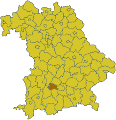
Fürstenfeldbruck is a cool rural area, also known as a district, located in the southern part of Bavaria, Germany. It's part of the Upper Bavaria area. Think of a district like a county or a region that groups together several towns and villages. Fürstenfeldbruck is known for its beautiful landscapes and friendly communities.
Contents
Exploring Fürstenfeldbruck
Fürstenfeldbruck is a district in the German state of Bavaria. It's located west of Munich, a very famous city in Germany. The district is named after its capital town, also called Fürstenfeldbruck.
What is a German District?
In Germany, a "district" (or Landkreis) is a type of local government area. It's bigger than a single town but smaller than a whole state. Districts help manage things like schools, roads, and public services for all the towns and villages within their borders.
Towns and Villages in Fürstenfeldbruck
The Fürstenfeldbruck district is made up of several towns and many smaller communities called municipalities. Each one has its own unique charm. Here are some of the places you can find in the district:
Main Towns
- Fürstenfeldbruck (the capital town)
- Germering
- Olching
- Puchheim
Other Municipalities
- Adelshofen
- Alling
- Althegnenberg
- Egenhofen
- Eichenau
- Emmering
- Grafrath
- Gröbenzell
- Hattenhofen
- Jesenwang
- Kottgeisering
- Landsberied
- Maisach
- Mammendorf
- Mittelstetten
- Moorenweis
- Oberschweinbach
- Schöngeising
- Türkenfeld
 | Delilah Pierce |
 | Gordon Parks |
 | Augusta Savage |
 | Charles Ethan Porter |

