Flaming Gorge, Utah facts for kids
Quick facts for kids
Flaming Gorge
|
|
|---|---|

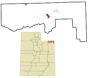
Location within Daggett County and the State of Utah
|
|

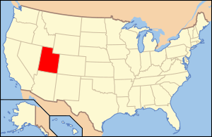
Location of Utah in the United States
|
|
| Country | United States |
| State | Utah |
| County | Daggett |
| Named for | Flaming Gorge National Recreation Area |
| Area | |
| • Total | 2.289 sq mi (5.93 km2) |
| • Land | 2.281 sq mi (5.91 km2) |
| • Water | 0.008 sq mi (0.02 km2) |
| Elevation | 6,919 ft (2,109 m) |
| Population
(2010)
|
|
| • Total | 83 |
| • Density | 36.26/sq mi (14.00/km2) |
| Time zone | UTC−7 (Mountain (MST)) |
| • Summer (DST) | UTC−6 (MDT) |
| Area code(s) | 435 |
| GNIS feature ID | 2584767 |
Flaming Gorge is a small community in Daggett County, Utah, United States. It is known as a census-designated place (CDP), which means it's a special area defined by the government for counting people. In 2010, only 83 people lived here.
Flaming Gorge is named after the famous Flaming Gorge National Recreation Area. This area is a popular spot for outdoor adventures.
Where is Flaming Gorge?
Flaming Gorge is located in the beautiful Flaming Gorge National Recreation Area. You can find it south of the large Flaming Gorge Reservoir. It is also north of a place called Greendale Junction.
Who Lives There?
In 2010, the community of Flaming Gorge had 83 residents. Most of the people living there were White. A small number of people were from other backgrounds. About 5% of the population identified as Hispanic or Latino. There were 109 housing units in the area.
What's the Weather Like?
Flaming Gorge has a type of weather called a warm-summer humid continental climate. This means it has warm summers and cold, snowy winters.
The hottest temperature ever recorded in Flaming Gorge was a scorching 102 degrees Fahrenheit (39 degrees Celsius) on July 14, 2002. Imagine how hot that would feel!
On the other hand, it can get extremely cold. The coldest temperature ever recorded was a freezing -38 degrees Fahrenheit (-39 degrees Celsius) on January 12, 1963. That's colder than most freezers!
Here is a detailed look at the weather patterns in Flaming Gorge:
| Climate data for Flaming Gorge, Utah, 1991–2020 normals, extremes 1957–present | |||||||||||||
|---|---|---|---|---|---|---|---|---|---|---|---|---|---|
| Month | Jan | Feb | Mar | Apr | May | Jun | Jul | Aug | Sep | Oct | Nov | Dec | Year |
| Record high °F (°C) | 60 (16) |
66 (19) |
76 (24) |
82 (28) |
93 (34) |
100 (38) |
102 (39) |
99 (37) |
99 (37) |
84 (29) |
75 (24) |
64 (18) |
102 (39) |
| Mean maximum °F (°C) | 50.0 (10.0) |
54.3 (12.4) |
65.3 (18.5) |
73.1 (22.8) |
82.3 (27.9) |
91.4 (33.0) |
95.7 (35.4) |
93.8 (34.3) |
87.6 (30.9) |
77.4 (25.2) |
62.6 (17.0) |
52.9 (11.6) |
96.2 (35.7) |
| Mean daily maximum °F (°C) | 36.6 (2.6) |
39.8 (4.3) |
49.6 (9.8) |
56.7 (13.7) |
67.1 (19.5) |
79.2 (26.2) |
86.8 (30.4) |
84.4 (29.1) |
75.4 (24.1) |
61.5 (16.4) |
46.4 (8.0) |
36.4 (2.4) |
60.0 (15.5) |
| Daily mean °F (°C) | 24.8 (−4.0) |
27.5 (−2.5) |
36.8 (2.7) |
43.6 (6.4) |
52.6 (11.4) |
62.3 (16.8) |
69.6 (20.9) |
68.0 (20.0) |
59.0 (15.0) |
46.7 (8.2) |
34.3 (1.3) |
24.9 (−3.9) |
45.8 (7.7) |
| Mean daily minimum °F (°C) | 13.0 (−10.6) |
15.1 (−9.4) |
24.0 (−4.4) |
30.4 (−0.9) |
38.1 (3.4) |
45.5 (7.5) |
52.4 (11.3) |
51.7 (10.9) |
42.6 (5.9) |
32.0 (0.0) |
22.1 (−5.5) |
13.4 (−10.3) |
31.7 (−0.2) |
| Mean minimum °F (°C) | −7.4 (−21.9) |
−8.3 (−22.4) |
4.3 (−15.4) |
14.1 (−9.9) |
23.5 (−4.7) |
32.2 (0.1) |
41.3 (5.2) |
39.8 (4.3) |
27.6 (−2.4) |
14.6 (−9.7) |
1.1 (−17.2) |
−7.2 (−21.8) |
−14.3 (−25.7) |
| Record low °F (°C) | −38 (−39) |
−31 (−35) |
−14 (−26) |
−1 (−18) |
14 (−10) |
22 (−6) |
30 (−1) |
26 (−3) |
11 (−12) |
−4 (−20) |
−17 (−27) |
−36 (−38) |
−38 (−39) |
| Average precipitation inches (mm) | 0.49 (12) |
0.66 (17) |
0.89 (23) |
1.10 (28) |
1.35 (34) |
0.94 (24) |
1.04 (26) |
1.19 (30) |
1.67 (42) |
1.37 (35) |
0.52 (13) |
0.54 (14) |
11.76 (298) |
| Average snowfall inches (cm) | 8.1 (21) |
8.6 (22) |
6.6 (17) |
3.6 (9.1) |
0.6 (1.5) |
0.0 (0.0) |
0.0 (0.0) |
0.0 (0.0) |
0.1 (0.25) |
2.4 (6.1) |
6.3 (16) |
7.4 (19) |
43.7 (111.95) |
| Average extreme snow depth inches (cm) | 6.1 (15) |
7.3 (19) |
4.2 (11) |
1.7 (4.3) |
0.5 (1.3) |
0.0 (0.0) |
0.0 (0.0) |
0.0 (0.0) |
0.0 (0.0) |
1.8 (4.6) |
3.1 (7.9) |
4.7 (12) |
9.7 (25) |
| Average precipitation days (≥ 0.01 in) | 4.0 | 4.2 | 5.7 | 6.2 | 6.6 | 5.3 | 5.3 | 6.4 | 5.6 | 5.3 | 4.0 | 4.2 | 62.8 |
| Average snowy days (≥ 0.1 in) | 3.6 | 3.3 | 2.9 | 1.6 | 0.2 | 0.0 | 0.0 | 0.0 | 0.1 | 1.0 | 2.7 | 3.4 | 18.8 |
| Source 1: NOAA | |||||||||||||
| Source 2: National Weather Service | |||||||||||||
See also
 In Spanish: Flaming Gorge (Utah) para niños
 | Georgia Louise Harris Brown |
 | Julian Abele |
 | Norma Merrick Sklarek |
 | William Sidney Pittman |

