Fort Foster (Washington County, Maine) facts for kids
Quick facts for kids |
|
|
"The Rim" and Site of Fort Foster
|
|

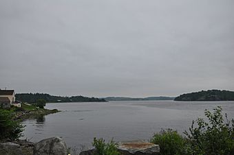
View toward The Rim from the south
|
|
| Nearest city | East Machias, Maine |
|---|---|
| Area | 200 acres (81 ha) |
| Built | 1775 |
| NRHP reference No. | 73000155 |
| Added to NRHP | July 23, 1973 |
Fort Foster was an important military spot during the American Revolutionary War in what is now East Machias, Maine. It was mostly a big dirt fort, built on a piece of land called The Rim. This land was perfect because it overlooked where the Machias and East Machias Rivers meet.
The fort was built in 1776. British soldiers attacked it in 1777 during the Battle of Machias. Today, this historic spot is recognized on the National Register of Historic Places since 1973.
Contents
What is Fort Foster?
Fort Foster was a military fort made of earthworks, which are walls or barriers built from earth. It was located on a special piece of land known as "The Rim." This land is a narrow strip that sits where the Machias River and the East Machias River come together.
The location was very strategic. It gave a clear view of the rivers and the bay. This made it an ideal spot to defend against enemy ships or soldiers trying to come up the rivers.
Why was The Rim important?
Machias Bay is in a part of Maine called Down East. The Machias River flows into this bay. The East Machias River also joins the Machias River before it reaches the bay.
Just before the East Machias River meets the Machias River, it makes a sharp turn. "The Rim" is the land between this bend and where the rivers join. In the 1700s, people realized this spot was great for military defense. It offered a commanding view of the rivers and the bay.
How Fort Foster was Built and Used
European settlers first came to this area in 1763. By the time the American Revolutionary War started in 1775, the land on The Rim was already cleared and used for farming.
Machias was famous for one of the war's first naval battles. In this fight, local people captured a British Navy ship. After this victory, the townspeople decided they needed to protect The Rim.
Early Defenses at The Rim
In the summer of 1775, a simple dirt wall, called a breastwork, was built on The Rim. This first defense was strong enough to stop British forces from landing there.
In 1776, they built an even bigger breastwork. They also added a watch house and barracks, which are buildings for soldiers to live in. To further block the river, a log boom was placed across it, just south of the fort.
The Battle of Machias (1777)
In August 1777, the British returned with a large force. During the second Battle of Machias, British soldiers landed on The Rim.
The guns at Fort Foster fired at the first British ships that arrived. However, the fort was left empty before the British fully landed. The fort's guns were then destroyed by the British.
What Happened to Fort Foster After the War?
After the Revolutionary War ended, Fort Foster was no longer used. The area became overgrown with plants and trees.
In the 1920s, the land was cleared again. This time, it was used for growing blueberries. Even then, the old dirt walls of the fort were still visible. Some of them were as tall as 6 feet (1.8 m)! Today, these earthworks have become overgrown once more.


