
Gasa District facts for kids
Quick facts for kids
Gasa
|
|
|---|---|
| Country | |
| Capital | Gasa Dzong |
| Area | |
| • Total | 3,117.74 km2 (1,203.77 sq mi) |
| Highest elevation | 4,500 m (14,800 ft) |
| Lowest elevation | 1,500 m (4,900 ft) |
| Population
(2005)
|
|
| • Total | 3,116 |
| • Estimate
(2010)
|
3,396 |
| • Density | 0.99944/km2 (2.5885/sq mi) |
| Time zone | UTC+6 (BTT) |
| • Summer (DST) | UTC+6 (not observed) |
Gasa District is one of the 20 main areas, called "dzongkhags," in the country of Bhutan. It is located in the northern part of Bhutan. The capital of Gasa District is a place called Gasa Dzong, which is near Gasa. This district is known for its beautiful mountains and hot springs.
Contents
About Gasa District
Gasa District is a special part of Bhutan. It is known for its stunning natural beauty. The district is home to high mountains, deep valleys, and many forests. It also has famous hot springs that people visit. The highest point in the district is about 4,500 meters (14,764 feet) high. The lowest point is around 1,500 meters (4,921 feet).
What is a Dzongkhag?
In Bhutan, a "dzongkhag" is like a province or a large district. It is a way to divide the country into smaller parts for easier management. Gasa is one of these 20 important areas.
Village Blocks
Gasa District is divided into four smaller areas called "gewogs" or village blocks. These blocks help manage the local communities. They are:
- Khamaed Gewog
- Khatoed Gewog
- Laya Gewog
- Lunana Gewog
The people living in these blocks often have unique cultures and traditions. They live in harmony with the nature around them.
Population and Size
In 2005, about 3,116 people lived in Gasa District. By 2010, the number grew slightly to about 3,396 people. The total area of Gasa District is about 3,117.74 square kilometers (1,203.77 square miles). This makes it one of the larger districts in Bhutan.
Images for kids
-
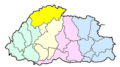
Map of Bhutan showing former borders of Gasa
-
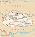
Map of Bhutan showing borders as of 2010


See also
 In Spanish: Distrito de Gasa para niños
