Gastineau Channel facts for kids
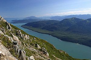
Gastineau Channel is a narrow waterway in Alaska, a state in the United States. It's known as Séet Ká in the Tlingit language. This channel separates the mainland of Alaska, where the city of Juneau is located, from Douglas Island. On Douglas Island, you'll find the community of Douglas, which is now part of Juneau.
The first European to see Gastineau Channel was Joseph Whidbey in August 1794. He saw it from both the south and the west. The channel was likely named after John Gastineau, an English civil engineer and surveyor.
Contents
What is Gastineau Channel Like?
Gastineau Channel is a long, narrow body of water. Large ships can only travel through its southeastern part. This section goes as far as the Douglas Bridge, which is about 9.7 miles (15.6 kilometers) long.
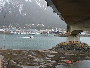
North of the Douglas Bridge, towards the Juneau International Airport, the channel becomes much shallower. In this area, which is about 8.1 miles (13 kilometers) long, only smaller boats can pass, and only when the tide is high.
Why is the Channel Getting Shallower?
The Gastineau Channel is becoming less deep, making it harder for boats to travel. There are two main reasons for this change:
- Land is rising: The land around the channel is slowly rising. This process is called isostatic rebound.
- Sediment is filling it in: Mud and silt are washing into the channel. This sediment comes from the Mendenhall Glacier and the Mendenhall River.
If these changes continue, Gastineau Channel might eventually become too shallow for any boats, or even dry up in some places.
Understanding Isostatic Rebound
Isostatic rebound happens when the Earth's crust, called the lithosphere, slowly rises. This occurs after a very heavy weight, like a large glacier, has been removed from its surface.
Think of it like an ice cube floating in a glass of water. If you put a penny on top of the ice cube, the ice cube sinks a little lower. This is similar to how a heavy glacier presses down on the Earth's crust. When you take the penny (the glacier) off, the ice cube (the crust) slowly "rebounds" and floats a bit higher.
In geology, this process happens very, very slowly. In southeastern Alaska, the land is rising at different speeds, from about 0.1 to 1.5 inches (0.25 to 3.8 centimeters) per year. This depends on how much ice was there in the past. Around Juneau, the land is rising by about 0.25 to 0.5 inches (0.6 to 1.2 centimeters) each year.
Learn More
 In Spanish: Canal Gastineau para niños
 | James Van Der Zee |
 | Alma Thomas |
 | Ellis Wilson |
 | Margaret Taylor-Burroughs |


