
Gettysburg Electric Railway facts for kids
The Gettysburg Electric Railway was a special electric trolley system in Gettysburg, Pennsylvania. It helped visitors explore the famous Gettysburg Battlefield during the summer. People used the trolley to see important battle sites, monuments, and even fun places like parks and a baseball field.
Even though a big court case in 1896 (called United States v. Gettysburg Electric Railway Co.) tried to stop the railway from using parts of the battlefield, the trolley kept running until 1916. The power plant that made electricity for the trolley also supplied power for streetlights and homes in Gettysburg for a while.
The trolley cars were quite large, carrying up to 94 passengers. They were called "Brill double-truck summer cars" and ran every 10 minutes on the main line, which was about 5.7 miles (9.2 km) long. The power plant was big too, measuring 150 by 100 feet (46 by 30 m), and used powerful steam engines to create electricity for the trolleys. Many people worked for the railway, including managers, conductors, and motormen who drove the cars.

The trolley line east of Plum Run extended to Round Top, Pennsylvania, through the Slaughter Pen, across Warren Av, through the Valley of Death, and across the north foot of Little Round Top to end behind the Round Top Station's warehouse.
|
|
| Overview | |
|---|---|
| Locale | Adams County, Pennsylvania Powerhouse: Gettysburg Terminus: Round Top |
| Operators |
|
| Dates of operation | 1894 (circaJuly) – 1916 November 16 |
History of the Gettysburg Trolley
_(14573162087).jpg)
The Gettysburg Electric Railway Company was officially started on August 4, 1891. By January 1893, the town of Gettysburg allowed the trolley to build tracks on its main streets. They planned to start running trolleys by July 1, 1893. The company even tried to get permission to build tracks west and north of the town, near the area of the First Day of the Battle of Gettysburg, but these plans never happened.
Building the tracks began in April 1893. The trolley line was extended from Wible's Woods to Round Top Station by April 1, 1894, with seven stops along the way. A new power plant was built after the first one burned down in January 1895. By October 1895, the railway had about 8.5 miles (13.7 km) of tracks.
A very important court case happened in 1896. The Supreme Court decided in the case of United States v. Gettysburg Electric Railway Co. that the government could take private land for "public use" if it was for something important like preserving historical sites. This decision was important for protecting the battlefield.
Trolley Accidents and Incidents
Like any transportation system, the Gettysburg Electric Railway had its share of accidents and incidents. In 1900, a power line broke, and in 1901, a car went off the tracks. In 1903, someone tried to make a trolley derail on purpose, and a motorman (the person driving the trolley) hit his head on an electric pole. One trolley car, named "Slocum," also jumped the tracks that year.
In 1904, a trolley hit a person named Joseph Keagy. Lightning storms sometimes caused problems, disabling the trolley operations in both 1904 and 1908. In 1909, the "Reynolds" trolley car crashed into an automobile. A year later, in August 1910, a trolley hit a person riding a horse. Just three days later, a serious collision occurred between the "Slocum" and "Sedgwick" cars near Devil's Den, causing one person to lose their life.
During the big 1913 Gettysburg reunion (a gathering of Civil War veterans), two trolley cars crashed near Devil's Den. In September of that year, a trolley in town was hit from behind when a passenger pulled the brake cable.
The last trolley car ran in November 1916. By then, the railway was getting old and needed repairs. Also, more and more tourists were using cars on the improved battlefield roads, making the trolley less popular. After 1917, the tracks were removed. There were plans to extend the trolley lines from Gettysburg to other cities like Chambersburg, Carlisle, Harrisburg, Philadelphia, and Baltimore, but these plans were never completed.
Images for kids
-
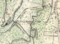
The trolley line east of Plum Run extended to Round Top, Pennsylvania, through the Slaughter Pen, across Warren Av, through the Valley of Death, and across the north foot of Little Round Top to end behind the Round Top Station's warehouse.
-
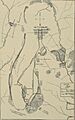
A map of the trolley network when it first opened in October 1893.
