Gitsegukla facts for kids
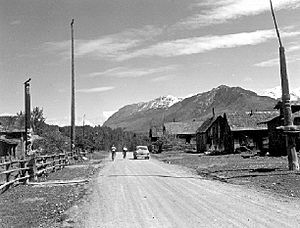
Gitsegukla (also known as Kitsegeucla or Skeena Crossing) is a small community in British Columbia, Canada. About 500 people live here. It's a special place where the Kitseguecla River meets the mighty Skeena River. This spot is about 40 kilometers southwest of Hazelton. Gitsegukla is part of the Gitxsan First Nation territory. The community is located on Gitsegukla Indian Reserve No. 1.
A Look Back in Time
The first Gitsegukla village was located near the Skeena River, close to where the graveyard is today. In 1872, something big happened. A group of miners were traveling through and didn't put out their campfire properly. This caused a fire that destroyed the village.
This event led to a serious disagreement between the Gitsegukla people and the miners. To solve the problem, the Lieutenant-Governor (a high-ranking government official) traveled on a warship called HMS Scout. He met with the Gitsegukla chiefs at Metlakatla. The chiefs received money and goods to make up for what they had lost.
After this, the community moved a little further up the river. Later, a church was built, and the village became divided by different religious groups. Some people who followed Methodism moved to a community called Carnaby. Others, who were part of the Salvation Army, moved to Andimaul. However, most people eventually returned to Gitsegukla in the years that followed.
Facing the Floods
The Skeena River has caused challenges for Gitsegukla over the years. In 1914, a very large flood swept away many homes in the second village. Then, in 1936, another huge flood hit. This time, the entire second village was washed away. Many important totem poles were also lost. Because of these floods, the community decided to build the current village site much higher up from the riverbank. This helps keep homes safer from future floods.
What's in a Name?
In the Gitxsan language, the name Gitsegukla has a special meaning. It roughly translates to "people living under the precipice." More specifically, it means living under the "Segukla" or "sharp-pointed" mountain. This name describes the unique landscape around the village.
 | Sharif Bey |
 | Hale Woodruff |
 | Richmond Barthé |
 | Purvis Young |


