
Hazelton, British Columbia facts for kids
Quick facts for kids
Village of Hazelton
|
|
|---|---|
|
village municipality
|
|

Northwestward aerial view at the confluence, Hazelton, 2011.
|
|

Hazelton, British Columbia
Location in British Columbia
|
|
| Country | Canada |
| Province | British Columbia |
| Region | Skeena |
| Regional district | Kitimat–Stikine |
| Incorporated | 1956 |
| Government | |
| • Type | Municipal corporation |
| Area | |
| • Total | 2.89 km2 (1.12 sq mi) |
| Elevation | 305 m (1,001 ft) |
| Population
(2021)
|
|
| • Total | 257 |
| • Density | 88.9/km2 (230.3/sq mi) |
| Time zone | UTC-8 (PST) |
| • Summer (DST) | UTC-7 (PDT) |
| Area codes | 250, 778, 236, & 672 |
| Highways | Hwy 62 |
| Waterways | Skeena River Bulkley River |
Hazelton is a small village in the Skeena region of west central British Columbia, Canada. It sits where the Skeena River and Bulkley River meet, forming a small piece of land. You can find Hazelton on BC Highway 62. It is about 75 kilometers (47 miles) northwest of Smithers and 144 kilometers (89 miles) northeast of Terrace. Hazelton is the first of three nearby communities, often called the "Three Hazeltons." The others are New Hazelton and South Hazelton.
Contents
- Geography of Hazelton
- First Nations and Early European Visitors
- How Hazelton Got Its Name
- Life Before the Railway Arrived
- Ferries and Bridges in Hazelton
- Hazelton After the Railway Arrived
- Population Changes in Hazelton
- Community Life in Hazelton
- Education in Hazelton
- Healthcare in Hazelton
- Climate in Hazelton
- Notable People from Hazelton
- Images for kids
Geography of Hazelton
The Skeena and Bulkley rivers flow through wide, forested valleys shaped by glaciers. The Roche de Boule mountain range forms the southern edge of the Skeena valley. To the north are the Skeena Mountains, and to the northwest are the Kispiox Range. The ground beneath Hazelton is made of layers of sandstone and shale. About 25,000 years ago, a thick ice sheet, about 2 kilometers (1.2 miles) deep, covered the area. Over the last 11,000 years, the rivers have carved through the thick layers of rock and soil, showing the older rock underneath.
First Nations and Early European Visitors
Who Lived in Hazelton First?
Indigenous peoples have lived in the Hazelton area for about 3,500 years. They were the first inhabitants of this land.
Early Explorers and Traders
In the 1840s, Simon McGillivray, a chief trader for the Hudson's Bay Company (HBC), explored the area that would become Hazelton. Later, in 1865, a survey team for the Russian–American Telegraph project traveled up the Skeena River to this spot. They left supplies for the construction workers who would arrive the next year.
In 1866, the telegraph line was built past the future Hazelton. It came from Quesnel through Fort Fraser. However, the line north of Quesnel was stopped in 1867.
From 1866 to 1868, the Hudson's Bay Company ran a fur trading post called Ackwilgate. It was located just south of the Bulkley River at Mission Point.
Gold Rush and Settlement Growth
The old telegraph trail became a path for people looking for gold. During the Omineca Gold Rush in 1870–1871, Hazelton became a very important place. Up to 4,000 miners used it as their base. After the gold rush ended, only a few European settlers remained.
In 1881, William Collison started an Anglican mission in Hazelton among the Gitxsan people. In 1888, a group of special police officers went to Hazelton to investigate a situation after a local person was killed.
The Anglican Church operated the Hazelton First Nations school from 1889 to 1950. This school received money from the federal government.

Ksan Historical Village: A Cultural Hub
In 1958, the first museum in town, called the House of Treasures, was built to show indigenous artifacts. In 1968, this building was moved to the Ksan Historical Village. This village was created as a place where local First Nations people could make, show, and sell their art and crafts. A special totem pole was carved for the village's opening in 1969. Artists carved items from wood or animal horn right there. By 1972, six traditional houses stood in a line, creating a real indigenous village.
Today, the Ksan Historical Village and Museum has seven decorated tribal houses with many carved totems. Visitors can watch carvers at work. The Ksan Dancers also perform traditional native dances at certain times.
How Hazelton Got Its Name
The area was first called The Forks in 1859, because of the two rivers meeting. The name Hazelton first appeared in 1872. Thomas Hankin, who settled the area in 1857, named it after the many hazelnut bushes growing nearby. For a while, both names were used, sometimes together, until the end of the 1800s.
Life Before the Railway Arrived
Early Businesses and Services
In 1870, the Cunningham & Hankin company, which later became R. Cunningham & Son, opened a store. By the early 1870s, Hazelton had a saloon and several stores. By 1874, only two stores remained.

In 1880, the Hudson's Bay Company bought a store. This became a place where supplies were sent from Hazelton to other HBC posts. By the late 1880s, a police officer was stationed in the community, and a jail was built.
From 1890 to 1915, Hazelton was the biggest community in northwest British Columbia. It was at the end of the navigable part of the Skeena River. This made it a busy center for gold prospectors, traders, merchants, and missionaries.
Steamboats and Telegraphs
In 1891, the HBC steamboat Caledonia was the first to travel through the difficult Kitselas Canyon and reach Hazelton. However, the canyon was often too high or too low for boats, limiting river travel to only three months a year.
In 1901, the federal government completed the Yukon Telegraph Trail. This telegraph line passed through Hazelton, connecting Ashcroft to the Alaskan border.

In 1900, St Peter's Anglican church was built. In 1907, a store and post office owned by R.S. Sargent burned down. People thought the Grand Trunk Pacific Railway (GTP) would come through Hazelton. This led to land sales nearby and a new interest in the town.
Growth and New Developments
In 1908, Joseph Leopold Coyle started the Omineca Herald newspaper. By this time, Hazelton had several stores and two hotels: the Hazelton and Omineca hotels. A weekly stagecoach ran southeast to Aldermere (near Telkwa) in summer, and sleighs in winter. In 1909, a new police district was created with its main office in Hazelton. New government offices and a new jail were also built.

In 1910, the Hazelton Hotel burned down. A fire department was formed, and the Union Bank opened a branch. A community hall was also built. By this time, a wagon road connected Hazelton southwest to Skeena Crossing.
In October 1911, P.E. Sands and his mechanic were the first to drive a car from Seattle to Hazelton. This was part of a plan for a big highway. They had to take their car apart and use horses for about 40 kilometers (25 miles) of the journey because there was no road. They were celebrated with a banquet in Hazelton.
.jpg)
In 1911, the rebuilt Hazelton Hotel opened with 32 guest rooms. The Bank of Vancouver also opened a branch. In 1912, several fires occurred, including one that destroyed the Hudson's Bay Company and Broughton & McNeil warehouses. This marked the end of an era when steamboats were the main way to get to Hazelton.
Ferries and Bridges in Hazelton
Connecting the Rivers
In 1910, a 184-foot (56-meter) suspension bridge opened across the Skeena River, about 1.5 miles (2.4 kilometers) north of Hazelton.
From 1911 to 1912, a ferry connected Sealey and Hazelton. In 1912, steamboats linked the railway head at Skeena Crossing with Hazelton.
A ferry across the Bulkley River, connecting Hazelton and South Hazelton, ran from mid-1912 until a low-level bridge replaced it in January 1917.
In July 1914, towers were built for the Skeena ferry, which was a large scow meant to replace canoes. A few days later, a boat attached to the ferry cable tipped over, and a young person drowned. By October, the ferry service was fully working.
In 1923–24, a new 10-ton (10-tonne) pontoon reaction ferry was installed.
New Bridges and Challenges
To replace older bridges, the rebuilt 400-foot (122-meter) Hagwilget suspension bridge officially opened in 1931. That same year, the Skeena ferry was carried downstream by the river. High water damaged the ferry again in 1935. During a flood in 1936, the ferry house floated away, and parts of the road were washed out.
In 1953, the ferry service was stopped.
Hazelton After the Railway Arrived
Changes and Challenges
In 1913, the Ingenica Hotel moved to New Hazelton, but the Hudson's Bay Company rebuilt its burned store in Hazelton. Sidewalks were built on Main Street. The number of cars in town grew to six.

In 1914, when the C.V. Smith store and residence burned down, it was rebuilt. The Royal Bank opened a branch in the building where the Bank of Vancouver had been. The Hudson's Bay Company store was also made bigger.
In 1915, the Royal Bank branch closed. In 1917, a store and laundry burned down, and the Omineca Herald newspaper moved to New Hazelton. The provincial government offices moved to Smithers. In 1918, the Omineca Miner newspaper stopped publishing.
On Christmas night in 1920, a large fire destroyed much of Hazelton's main business area. In January 1921, another fire broke out in the old Ingenica Hotel, and a person died. A few months later, the RCMP main office moved to Telkwa, leaving only one police officer in Hazelton. In 1922, the Hazelton Methodist Church was built. In April of that year, another fire destroyed the Hazelton Hotel and several other buildings. In 1925, the Royal Bank took over the Union Bank's local branch.

In 1931, the Omineca Hotel and other buildings were destroyed by fire. In 1932, the Royal Bank branch closed, and a hotel and two warehouses also burned down.
Modern Developments
In 1947, Canadian Trailway Stages started a bus service from Hazelton to Prince George. In 1948, the First Nations band allowed 36 acres (15 hectares) of their reserve land to be sold for public housing, which increased the size of Hazelton.

In 1949, the BC Power Commission took over the local electricity supply. They expanded power lines to South Hazelton and New Hazelton. In 1956, Hazelton officially became a village. The Inlander Hotel opened that year, and the Royal Bank rented its lower level before building its own branch across the street. In 1959, the Royal Bank in Hazelton became a full branch, and the New Hazelton branch closed.
In 1963, BC Hydro increased the electricity supply. From 1965 to 1972, the streets were paved for the first time. In 1969, the current one-story brick post office was built. Later that year, a modern dial telephone system replaced human operators.
In 1972, a new lounge opened at the Inlander Hotel. In July 1979, a special weekend was held for former residents to come back and visit. By the early 1980s, the RCMP police services were moved to New Hazelton. In 1997, the Royal Bank moved its branch to Hagwilget.
Population Changes in Hazelton
| Census population: Hazelton |
||
|---|---|---|
| Year | Pop. | ±% |
| 1956 | 279 | — |
| 1961 | 410 | +47.0% |
| 1966 | 403 | −1.7% |
| 1971 | 351 | −12.9% |
| 1976 | 371 | +5.7% |
| 1981 | 393 | +5.9% |
| 1986 | 436 | +10.9% |
| 1991 | 339 | −22.2% |
| 1996 | 347 | +2.4% |
| 2001 | 345 | −0.6% |
| 2006 | 293 | −15.1% |
| 2011 | 270 | −7.8% |
| 2016 | 313 | +15.9% |
| 2021 | 257 | −17.9% |
In the 2021 Census, Hazelton had a population of 257 people. They lived in 113 homes. This was a decrease from its 2016 population of 313 people. The village covers a land area of 2.89 square kilometers (1.12 square miles).
Community Life in Hazelton
Recent Developments
In 2003, a fire badly damaged the Inlander Hotel. In 2017, BC Transit started a bus service connecting Terrace and the Hazeltons, which is still running today. In 2023, construction began on a new three-story building near the hospital. This building will provide 31 new affordable rental homes.
Things to See and Do
You can take a walking tour of downtown Hazelton. This tour includes displays of old pioneer machinery, an original steam donkey (a type of steam engine), and historical sites. There is also the Pioneer Museum, a replica of a riverboat, and the historic St. Peter's Anglican Church.
Education in Hazelton
Early Schools
In 1906, a one-room school opened in a building provided for free by the Hudson's Bay Company. By 1913, this building was too small for the 23 students, so a new schoolhouse was built.
In 1926, the school became a rural school. In 1930, a second classroom was added. From 1948 to 1949, the school became Hazelton Elementary-Senior High. It was described as a modern school with seven rooms and seven teachers.
Modern Schools
In 1962–63, the Two Mile elementary school opened. In 1963–64, John Field Elementary opened in Hazelton. In 1965–66, Hazelton Elementary-Senior High became Hazelton Secondary. The two-room Two Mile school closed in 1979.
In March 1992, a new Hazelton Secondary school building was constructed, replacing the old one. In 2014, John Field Elementary was renamed Majagaleehl Gali Aks. This name means "flowers of the rivers" in the Gitxsan language.
Hazelton's schools are part of School District 82 Coast Mountains. Majagaleehl Gali Aks is located on the way down to the downtown area. Hazelton Secondary, which is northeast of the elementary school, has about 375 students. Next to the secondary school is a campus of the Coast Mountain College.
Healthcare in Hazelton
Hazelton Hospital History
In 1904, Dr. Horace Cooper Wrinch opened the first hospital in Hazelton. This hospital also had a nursing school, gardens, and a dairy farm. The Methodist Church owned the hospital, and it received money from the church, the province, and the public.

The main hospital building was two stories tall with an attic and basement. In 1904, it had five staff members and 13 beds. By 1911, it had 12 staff and 33 beds, thanks to a new wing added in 1910. Patients could choose private, semi-private, or public care. By that time, 25 acres (10 hectares) of land were used to grow vegetables and animal feed.
By 1912, 30 acres (12 hectares) of the 300-acre (121-hectare) hospital grounds were cleared. A lake on the property was 80 acres (32 hectares), and birch trees formed a 7-acre (2.8-hectare) natural park. In 1914, the hospital got electricity.
When the hospital was rebuilt for the second time in 1930, it was renamed the Wrinch Memorial Hospital.
Modern Healthcare Services
By 1972, the hospital had 50 beds and plans to double its size. A new single-story building, 46,300 square feet (4,300 square meters) in size, opened next to the existing hospital in 1977.
In 2002, the province decided not to make the hospital smaller. It kept its nine acute care beds, long-term care beds, and its role in teaching.
Today, the hospital is part of Northern Health. It provides care for urgent needs, complex medical conditions, and community health. It also offers assisted living and both short-term and long-term accommodation. The hospital has double rooms, including 10 publicly funded long-term care beds. It also supports outpatient care, where people visit for treatment and then go home. A BCAS station is located on the hospital grounds.
Climate in Hazelton
Hazelton has a humid continental climate. This means it has cold winters and warm summers. Winters are milder than you might expect for this far north, thanks to air coming from the Pacific Ocean. The average temperature in January is -8.1°C (17.4°F). From December to February, the temperature reaches or goes above freezing about 32 days on average. However, very cold Arctic air can sometimes push temperatures below -30.0°C (-22.0°F), which happens about three days a year. The average yearly snowfall is 185 centimeters (73 inches).
Summers are warm, with an average daytime high of 23.6°C (74.5°F) in July. However, nights are cool, with a July low of 9.3°C (48.7°F). In an average summer, the temperature goes above 30°C (86°F) about seven days. The average yearly rainfall is 614 millimeters (24.2 inches). March and April are the driest months, while October through January are wetter. The highest temperature ever recorded was 36.7°C (98.1°F) on August 20, 1977. The lowest temperature ever recorded was -40.5°C (-40.9°F) on January 8, 1991.
| Climate data for Hazelton | |||||||||||||
|---|---|---|---|---|---|---|---|---|---|---|---|---|---|
| Month | Jan | Feb | Mar | Apr | May | Jun | Jul | Aug | Sep | Oct | Nov | Dec | Year |
| Record high °C (°F) | 8.9 (48.0) |
11.0 (51.8) |
17.0 (62.6) |
26.7 (80.1) |
32.5 (90.5) |
34.5 (94.1) |
36.0 (96.8) |
36.7 (98.1) |
32.2 (90.0) |
21.5 (70.7) |
12.5 (54.5) |
8.0 (46.4) |
36.7 (98.1) |
| Mean daily maximum °C (°F) | −4.7 (23.5) |
0.2 (32.4) |
7.1 (44.8) |
13.1 (55.6) |
17.9 (64.2) |
21.1 (70.0) |
23.6 (74.5) |
23.0 (73.4) |
17.2 (63.0) |
9.5 (49.1) |
0.6 (33.1) |
−4.4 (24.1) |
10.4 (50.6) |
| Daily mean °C (°F) | −8.1 (17.4) |
−4.3 (24.3) |
1.2 (34.2) |
6.2 (43.2) |
10.8 (51.4) |
14.0 (57.2) |
16.4 (61.5) |
15.9 (60.6) |
11.5 (52.7) |
5.4 (41.7) |
−2.0 (28.4) |
−7.3 (18.9) |
5.0 (41.0) |
| Mean daily minimum °C (°F) | −11.4 (11.5) |
−8.8 (16.2) |
−4.6 (23.7) |
−0.8 (30.6) |
3.5 (38.3) |
6.8 (44.2) |
9.3 (48.7) |
8.8 (47.8) |
5.7 (42.3) |
1.3 (34.3) |
−4.6 (23.7) |
−10.2 (13.6) |
−0.4 (31.2) |
| Record low °C (°F) | −40.5 (−40.9) |
−35.0 (−31.0) |
−30.0 (−22.0) |
−11.1 (12.0) |
−5.0 (23.0) |
−1.1 (30.0) |
0.0 (32.0) |
−0.5 (31.1) |
−4.0 (24.8) |
−22.0 (−7.6) |
−32.5 (−26.5) |
−39.0 (−38.2) |
−40.5 (−40.9) |
| Average precipitation mm (inches) | 69.0 (2.72) |
39.2 (1.54) |
23.5 (0.93) |
31.0 (1.22) |
41.4 (1.63) |
56.4 (2.22) |
47.1 (1.85) |
47.5 (1.87) |
62.1 (2.44) |
74.2 (2.92) |
71.7 (2.82) |
62.2 (2.45) |
625.3 (24.61) |
| Average rainfall mm (inches) | 12.8 (0.50) |
13.4 (0.53) |
13.6 (0.54) |
28.6 (1.13) |
41.4 (1.63) |
56.4 (2.22) |
47.1 (1.85) |
47.5 (1.87) |
62.1 (2.44) |
70.8 (2.79) |
31.9 (1.26) |
10.0 (0.39) |
435.6 (17.15) |
| Average snowfall cm (inches) | 56.2 (22.1) |
25.8 (10.2) |
9.9 (3.9) |
2.4 (0.9) |
0 (0) |
0 (0) |
0 (0) |
0 (0) |
0 (0) |
3.4 (1.3) |
39.8 (15.7) |
52.2 (20.6) |
189.7 (74.7) |
| Average precipitation days (≥ 0.2 mm) | 15.1 | 10.9 | 9.2 | 11.2 | 14.1 | 14.1 | 12.6 | 12.9 | 15.7 | 17.9 | 17.2 | 13.9 | 164.8 |
| Average rainy days (≥ 0.2 mm) | 4.2 | 5.1 | 6.7 | 11.1 | 14.1 | 14.1 | 12.6 | 12.9 | 15.7 | 17.4 | 8.7 | 3.3 | 125.9 |
| Average snowy days (≥ 0.2 cm) | 12.1 | 7.2 | 3.7 | 0.41 | 0 | 0 | 0 | 0 | 0 | 1.1 | 10.8 | 12.6 | 47.91 |
| Source: Environment Canada1981-2010 | |||||||||||||
Notable People from Hazelton
Hazelton has been home to several interesting people, including:
- Lyndsay Belisle (born 1977), an Olympic wrestler who was born and lived here.
- Jean-Jacques Caux, also known as Cataline (around 1830–1922), who operated pack trains and lived here until his death.
- Sperry Cline (1881–1964), a police officer and author.
- Constance Cox (around 1881–1960), a schoolteacher and interpreter who was born and lived here.
- Doug Donaldson (born 1957), a politician who lives in Hazelton.
- Dave Hancock (born 1955), a judge and politician who lived here as a child.
- Ron Homenuke (born 1952), an ice hockey player who was born here.
- Vicki Huntington (born in the 19??s), a politician who lives in Hazelton.
- Carol Huynh (born 1980), an Olympic wrestler who was born and lives here.
- Simon Peter Johnson, also known as Simon Gunanoot (1874–1933), a merchant who lived in Hazelton.
- Alan Kerr (born 1964), an ice hockey player who was born and lives here.
- Cathy McMorris Rodgers (born 1969), a politician who lived here as a child.
- Roy Henry Vickers (born 1946), an indigenous artist and author who lives in Hazelton.
Images for kids
-
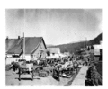
Cataline's Mule Train, Hazelton, 1911.
-
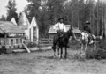
Simon Gunanoot (left), indigenous cemetery, Hazelton, 1920.


