Golspie, New South Wales facts for kids
Quick facts for kids GolspieNew South Wales |
|||||||||||||||
|---|---|---|---|---|---|---|---|---|---|---|---|---|---|---|---|

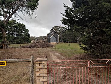
Church in Golspie
|
|||||||||||||||
| Population | 58 (2016 census) | ||||||||||||||
| Postcode(s) | 2580 | ||||||||||||||
| Elevation | 876 m (2,874 ft) | ||||||||||||||
| Location | |||||||||||||||
| LGA(s) | Upper Lachlan Shire | ||||||||||||||
| Region | Southern Tablelands | ||||||||||||||
| County | Georgiana | ||||||||||||||
| Parish | Hillas | ||||||||||||||
| State electorate(s) | Goulburn | ||||||||||||||
| Federal Division(s) | Hume | ||||||||||||||
|
|||||||||||||||
Golspie is a small place in the Upper Lachlan Shire of New South Wales, Australia. It's mostly known for its farms, especially those raising animals like sheep and cattle. In 2016, only 58 people lived there, making it a very quiet community. The towns closest to Golspie are Taralga and Crookwell.
Contents
Where is Golspie?
Golspie is located in a part of New South Wales called the Southern Tablelands. This area is known for its rolling hills and open spaces. It's about 261 kilometers (162 miles) west-southwest of Sydney, Australia's largest city. The elevation of Golspie is 876 meters (2,874 feet) above sea level. This means it's quite high up, which can affect the weather.
Nearby Towns and Cities
Golspie is surrounded by other small towns and larger cities.
- Crookwell is about 37 kilometers (23 miles) northeast.
- Goulburn is about 68 kilometers (42 miles) north.
- Bathurst is about 143 kilometers (89 miles) south.
These connections help link Golspie to bigger places for supplies and services.
Life in Golspie
Life in Golspie is very much connected to the land. Since it's a livestock farming area, many people work with animals. This could mean raising sheep for wool or meat, or cattle for beef. Farming is a big part of the local economy and way of life.
Community and History
Even though Golspie is small, it has a community feel. Places like the local church, shown in the infobox, are important gathering spots. Small towns like Golspie often have a rich history, with families living and farming in the area for many generations. They play a key role in Australia's agricultural industry.
Nature Around Golspie
The Southern Tablelands region, where Golspie is found, has a unique natural environment. You might see native Australian animals like kangaroos and wallabies in the fields. The area also has various types of trees and plants that are suited to the climate.
Local Wildlife
- Kangaroos: These famous marsupials are common in rural Australia.
- Wallabies: Smaller relatives of kangaroos, often found in bushland.
- Birds: Many different bird species live in the region, including parrots and kookaburras.
Understanding the local environment helps us appreciate the natural beauty of places like Golspie.


