Gordon–Schaust Site facts for kids
Quick facts for kids |
|
|
Gordon-Schaust Site
|
|

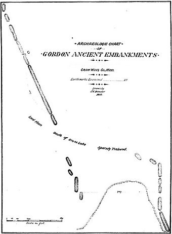
1901 survey map of the Gordon Embankments
|
|
| Location | Address restricted , Crosslake, Minnesota |
|---|---|
| Built | Undetermined |
| NRHP reference No. | 74001015 |
| Designated HD | December 23, 1974 |
The Gordon–Schaust Site is an ancient Native American place in Crosslake, Minnesota. It has two groups of long, low mounds. These mounds are very old, but we don't know their exact age. They are also very well kept. This site was added to the National Register of Historic Places in 1974 because it is very important for understanding history through archaeology in Minnesota.
Discovering the Mounds
The first group of mounds was found by Jacob V. Brower. He was exploring the area in 1897 and again in 1901. He called them the Gordon Embankments. An "embankment" is like a long, raised bank of earth.
Later, in 1972, the Minnesota Historical Society looked at the area again. They found a second group of mounds nearby. These new mounds were almost exactly like the first ones. They named this second group the Schaust Embankments.
What Are These Mounds Like?
The Gordon Embankments have 20 mounds. Most of them are long and straight. Four of these mounds run north to south. The others point a bit to the northwest. The longest mound is about 146 meters (480 feet) long.
Jacob Brower said the mounds were about 6 meters (20 feet) wide. He also noted they were about 0.76 meters (2.5 feet) high. The whole group of Gordon mounds stretches for about 317 meters (1040 feet).
Both the Gordon and Schaust groups are made of long mounds. They mostly lie end to end. This is different from other mound sites nearby. For example, the Upper Hay Lake Mounds are in rows. The Fort Flatmouth Mounds form a rough circle.

