Upper Hay Lake Archeological District facts for kids
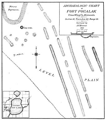
The Upper Hay Lake Archeological District is a very old Native American site in Jenkins Township, Minnesota. It's a special place where archaeologists study the past. This area has about 75 long, low hills called mounds. One of these mounds is super long, stretching for about 725 feet (221 meters)!
This district also includes the remains of an old village and a portage. A portage is a path where people carried their canoes and boats between two bodies of water. The group of mounds is also known by a cool nickname: Fort Poualak.
This important site was added to the National Register of Historic Places in 1978. This means it's recognized as a special place that helps us understand the history of people who lived here long ago, especially during the Late Woodland period.
Contents
What is the Upper Hay Lake Archeological District?
The Upper Hay Lake Archeological District has two main parts. One part is an old village site right by the shore of Upper Hay Lake. The other part is the group of mounds, also called Fort Poualak. This mound area is about 900 feet (274 meters) northwest of the village. Even though they are slightly separate, archaeologists consider them one big, important site.
What do the Mounds Look Like?
The long mounds are arranged in five rows, like lines on a field. These rows are about 50 to 60 feet (15 to 18 meters) apart. The two rows on the east side are shorter, only about 230 feet (70 meters) long. The longer rows have small gaps in them, usually 20 to 50 feet (6 to 15 meters) wide. The longest single mound without any breaks is about 725 feet (221 meters) long. Early explorers also noticed a round dip in the ground nearby, which might have been where an old lodge (a type of house) once stood.
Who Studied the Site?
The Upper Hay Lake site has been studied by different people over the years.
Early Discoveries by Jacob V. Brower
A man named Jacob V. Brower was the first to write about this site in 1897. He dug into one of the mounds and found some old bone material. He came back in May 1901 to do a more detailed study. Brower carefully figured out that the mounds were built using a huge amount of soil, about 10,108 tons (9,170 metric tons)! He was also the one who gave the mound area its nickname, "Fort Poualak."
Frithiof T. Gustavson's Finds
In the 1930s, a local person named Frithiof T. Gustavson became very interested in archaeology. He did his own digging at the site and found several artifacts. One of his most exciting finds was a whole ceramic pot, which became known as the "Fort Poualak Pot." Gustavson loved to show off his discoveries. He gave talks at schools and county fairs, sharing the history of the area. He later became the superintendent of a museum in Cass Lake.
Gustavson's family later gave the Fort Poualak Pot to the Minnesota Historical Society in 1997. Experts studied the pot and found it was made in a style called St. Croix Stamped ware. They also used a method called radiocarbon dating to find out how old it was. They learned that the pot was made around 550 CE (Common Era). When they looked closely at the inside of the pot, they found tiny bits of wild rice, which tells us what people might have eaten or stored in it long ago.
Modern Surveys
More recently, in 2010, there were worries that logging might have damaged the site. So, the state used special technology called Lidar to survey the area. Lidar uses lasers to create detailed maps of the ground. This survey showed that only about 50 of the original mounds are still there today.


