Grécourt facts for kids
Quick facts for kids
Grécourt
|
|
|---|---|
|
Part of Hombleux
|
|

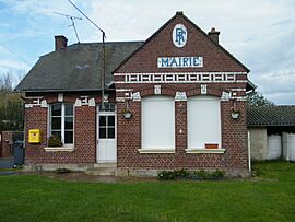
The town hall in Grécourt
|
|
| Country | France |
| Region | Hauts-de-France |
| Department | Somme |
| Arrondissement | Péronne |
| Canton | Ham |
| Commune | Hombleux |
| Area
1
|
2.34 km2 (0.90 sq mi) |
| Population
(2016)
|
21 |
| • Density | 8.97/km2 (23.2/sq mi) |
| Time zone | UTC+01:00 (CET) |
| • Summer (DST) | UTC+02:00 (CEST) |
| Postal code |
80400
|
| Elevation | 61–71 m (200–233 ft) (avg. 65 m or 213 ft) |
| 1 French Land Register data, which excludes lakes, ponds, glaciers > 1 km2 (0.386 sq mi or 247 acres) and river estuaries. | |
Grécourt (French pronunciation: [ɡʁekuʁ]) was a small village in northern France. It used to be its own commune, which is like a local government area or a small town. Grécourt is located in a part of France called the Somme department. This department is part of the larger Hauts-de-France region. On January 1, 2019, Grécourt joined with another commune called Hombleux. This means it is no longer a separate commune.
Where is Grécourt?
Grécourt is located in the Somme department of France. It sits on a road known as the D114. This road helps people travel to and from the village. The village is about 8 kilometers (or 5 miles) east of a town called Roye.
How Many People Lived There?
Like many small villages, the number of people living in Grécourt changed over the years. We can look at population records to see how many people lived there at different times. These numbers help us understand the history of the village.
| 1962 | 1968 | 1975 | 1982 | 1990 | 1999 | 2006 |
|---|---|---|---|---|---|---|
| 28 | 30 | 19 | 25 | 24 | 26 | 24 |
See also
 In Spanish: Grécourt para niños


