
Guatapé facts for kids
Quick facts for kids
Guatapé
|
|||
|---|---|---|---|
|
Municipality and town
|
|||
com.jpg)
Aerial image of Guatapé and in the background the Piedra del Peñol
|
|||
|
|||

Location of the municipality and town of Guatapé in the Antioquia Department of Colombia
|
|||
| Country | |||
| Department | |||
| Subregion | Eastern | ||
| Elevation | 1,890 m (6,200 ft) | ||
| Demonym(s) | Guatapenses Guatapeños |
||
| Time zone | UTC-5 (Colombia Standard Time) | ||


Guatapé is a vibrant town and municipality in the Department of Antioquia, Colombia. It is part of the Eastern Antioquia region. The town is located about 79 kilometers (49 miles) from Medellín, which is the capital city of the department. Guatapé sits at an altitude of 1,890 meters (6,200 feet) above sea level.
This charming town is a major tourist destination, especially for visitors from Medellín. Two of its most famous attractions are El Peñón de Guatapé, a giant rock that people can climb, and the unique zócalos (colorful murals) that decorate many of its buildings.
Contents
History of Guatapé
Early Inhabitants and Naming
Before Spanish explorers arrived in the 1500s, the area where Guatapé now stands was home to indigenous groups. Some of these groups were led by a respected leader named Guatapé. The town was later named in his honor. The name "Guatapé" comes from the Quechua language, meaning "stones and water."
In 1714, the indigenous people of this region were brought together in a settlement called "San Antonio de Remolinos Peñol." We know they lived here because clay pots have been found in Alto Verde, and there are other ancient sites nearby.
Founding and Development
Guatapé was officially founded on October 4, 1811, by a Spaniard named Don Francisco Giraldo y Jimenez. It became a recognized municipality in September 1867.
For a long time, Guatapé was mainly a farming town. Its economy relied on raising livestock, growing crops, and some mining. However, things changed a lot in the 1970s.
The Hydroelectric Dam Project
In the 1970s, a large company called Empresas Públicas de Medellín built a huge hydroelectric power plant here. This big project created a large reservoir, which changed the town significantly. Guatapé became one of the most important places for producing electricity in Colombia.
The construction of the dam caused the valley to flood, which meant that the neighboring town of El Peñol and parts of Guatapé had to be moved. Thousands of people had to leave their homes, and the town of El Peñol was rebuilt a few miles west of its original spot.
Guatapé's Population
Guatapé is home to many friendly people. As of 2015, the total population was 6,469 inhabitants. Most people live in the urban area (5,045), while fewer live in the rural areas (1,424). The town also has a high literacy rate, meaning most people can read and write. In 2005, the literacy rate was 92.3%.
Fun Places to Visit in Guatapé

Guatapé offers many interesting places for visitors to explore:
- Calle del Recuerdo ("Memory Lane"): A special street that reminds people of the town's history.
- El Peñol-Guatapé Reservoir: The large lake created by the dam, perfect for boat rides and water activities.
- El Peñón de Guatapé: The famous giant rock you can climb.
- Parish Church of Nuestra Señora del Carmen: A beautiful church in the town center.
- Chapel of Our Lady of Santa Ana: Another lovely chapel.
- Community Historical Museum: A place to learn about Guatapé's past.
- Pueblo de Zócalos: The town itself, famous for its unique decorated buildings.
Climbing El Peñón de Guatapé
_2017-04-10.jpg)
El Peñón de Guatapé is a huge rock formation that stands next to the reservoir. It formed about 70 million years ago. Most of the rock is actually underground, but the part you can see is over 200 meters (650 feet) tall! It's so big you can see it from far away.
Visitors can climb to the top of the rock using a staircase built into one side. This path has more than 708 steps, and the view from the top is amazing!
The Famous Zócalos
One of the most unique things about Guatapé is its zócalos. These are colorful tiles and raised images that decorate the lower parts of buildings. Each building has its own special design. Many of these designs show what the shops sell, or they represent the beliefs of the people who live there. Others show scenes from the community's farming history, making the town look like a giant outdoor art gallery!
Gallery
-
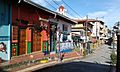
Typical street scene in Guatapé
-
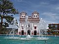
Church of Our Lady of Carmen
-
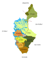
Map of neighborhoods and veredas
-

El Peñol-Guatapé Reservoir


See also
 In Spanish: Guatapé para niños
