Hat Head, New South Wales facts for kids
Quick facts for kids Hat HeadNew South Wales |
|
|---|---|

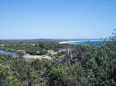
View on Hat Head from Korogoro Point
|
|
| Postcode(s) | 2440 |
| Location |
|
| LGA(s) | Kempsey Shire |
| State electorate(s) | Oxley |
| Federal Division(s) | Cowper |
Hat Head is a small town right on the coast of New South Wales, Australia. It's located on the beautiful Mid North Coast, about 459 kilometres north of Sydney. This town is special because it's surrounded by the amazing Hat Head National Park.
In 2021, a count of people called a census showed that 365 people lived in Hat Head.
About Hat Head
Hat Head is part of the Kempsey Shire area. It is a bit isolated, meaning it's not very close to big cities. The town is mostly known as a fishing village. Many people also visit it for fishing holidays.
About 350 people live here all the time. The town is built on sand, with the national park and water all around it. There isn't much land left for new buildings. This makes properties in Hat Head quite valuable. They can be much more expensive than in other parts of the Kempsey Shire.
Town Features
Hat Head has some great facilities for its community. There is a library where you can use the internet. This library is part of the Nicholl Community Centre. The town also has a small church and tennis courts.
Kids can enjoy a covered playground. There is also a special viewing platform at the beach. This platform makes it easy for everyone, including those with disabilities, to enjoy the ocean views.
Straight Street and the Creek
Straight Street is the main road in Hat Head. It is actually lower than sea level. However, the town has not had any major floods for many years. This is thanks to a special flood gate.
The flood gate stops fresh water from Korogoro Creek flowing into the village. This creek starts at a wetland called Swan Pool. The gate helps control the water flow. Opening the gates sometimes during small floods can help keep the creek healthy.
How Hat Head Grew
Hat Head was not easy to reach for a long time. Because of this, the area only started to develop in the early 1900s. Some old photos show the first buildings and people enjoying their time there.
| Historical population | ||
|---|---|---|
| Year | Pop. | ±% |
| 1976 | 280 | — |
| 1981 | 330 | +17.9% |
| 1986 | 355 | +7.6% |
| 1991 | 349 | −1.7% |
| 1996 | 334 | −4.3% |
| 2001 | 319 | −4.5% |
| 2006 | 298 | −6.6% |
| 2011 | 326 | +9.4% |
| 2016 | 302 | −7.4% |
| 2021 | 365 | +20.9% |
| Source: Australian Bureau of Statistics data. | ||
 | Valerie Thomas |
 | Frederick McKinley Jones |
 | George Edward Alcorn Jr. |
 | Thomas Mensah |


