
Hobsonville facts for kids
Quick facts for kids
Hobsonville
|
|
|---|---|
|
Suburb
|
|
.jpg) |
|

Hobsonville
Location in New Zealand
|
|
| Country | New Zealand |
| Local authority | Auckland |
| Electoral ward | Albany ward |
| Local board | Upper Harbour Local Board |
| Area | |
| • Land | 642 ha (1,586 acre) |
| Population
(June 2023)
|
|
| • Total | 12,360 |
| Postcode(s) |
0618
|
| Ferry terminal(s) | Hobsonville Point |
|
|
||
Hobsonville is a suburb located in West Auckland, New Zealand. It sits on the North Island and has grown from a quiet farming area into a busy part of Auckland.
This area was one of the first places in Auckland where Europeans settled. It became very important for making pottery in New Zealand's early days. Later, Hobsonville was home to a Royal New Zealand Air Force (RNZAF) base from 1920 to 2001. After the air base closed, a big plan was made to build many new homes here.
The Hobsonville peninsula is connected by State Highway 16 on its west side. The Upper Harbour Bridge connects it on the east.
Contents
- What is Hobsonville's Geography Like?
- Discovering Hobsonville's Past
- Hobsonville's Modern Development
- Who Lives in Hobsonville?
- What is Hobsonville's Economy Like?
- Learning in Hobsonville: Schools and Education
- How Do People Travel in Hobsonville?
- Important Places to See in Hobsonville
- What Can You Do in Hobsonville?
- 2012 Tornado Event
- Images for kids
What is Hobsonville's Geography Like?

Hobsonville is a peninsula, which means it's a piece of land mostly surrounded by water. It lies between the Upper Waitematā Harbour and the main Waitematā Harbour.
Discovering Hobsonville's Past
Early Settlement and Pottery Industry


Hobsonville got its name from William Hobson, who was the first Governor of New Zealand. When he first arrived by sea, he thought this spot would be a good place for New Zealand's government. However, he later changed his mind. After the Treaty of Waitangi was signed, Okiato (which was later renamed Russell) became the capital instead.
The New Zealand government bought Hobsonville in 1853. At that time, maps described it as mostly covered in ferns. A post office opened in Hobsonville in 1886. By 1908, it had become a town district.
The first European settler, Rice Owen Clark, bought land here in 1854. The ground was too wet for farming, so Clark started using the land for clay production. In the early days of Auckland, large factories that made clay products and bricks operated in areas like Limeburners Bay. Hobsonville was a major center for making heavy clay products from 1863 to 1929. These factories specialized in items like drain pipes, garden decorations, and household dishes. Under Clark's son, Rice Owen Clark II, the pottery works grew to be the largest in the southern hemisphere.
Other pottery businesses also existed in the area. Joshua Carder, a potter from England, started his works in late 1863. Robert Holland set up in Limeburners Bay around 1904, but Clark bought his business five years later. Ockleston's pottery, started in 1903, was also bought by Clark around the same time.
However, much of the land remained undeveloped. In 1929, the clayworks closed because it became too expensive to transport the clay, which was running out. During the Great Depression, the clay industries in West Auckland combined. They moved their main operations to New Lynn.
You can still find old broken pieces of pottery along the shore near Limeburners Bay today. These are reminders of the area's pottery past.
Hobsonville's Air Force History
In November 1925, Henry Clark sold 167 acres of land in Hobsonville to the New Zealand Permanent Air Force. This land was farmland with a few buildings. By 1929, the air base had an office, a control hut, a boat shed, a hangar, a jetty, and a slipway. It also had several houses for the airmen. The Hobsonville airbase even had a pigeon loft. They used carrier pigeons for messages before they got wireless radio equipment.

Many historic buildings from the 1920s and 1930s still stand at Hobsonville. These include homes for officers, barracks (buildings for soldiers), and hangars. These hangars were used to store seaplanes (planes that land on water) and helicopters.
In September 1938, New Zealand started making a list of potential tradesmen and ground staff for the RNZAF. This was because of the "Munich crisis," which made it seem like war could start at any time. The RNZAF grew so quickly before the war that its training school at Hobsonville couldn't train enough mechanics and technicians.
After World War II ended, 30 North American P-51 Mustang planes arrived in New Zealand. These planes were no longer needed, so they were stored at Hobsonville. They were later moved to other locations and eventually used by the New Zealand Territorial Air Force.
In 1965, the Hobsonville air station joined with the airfield at Whenuapai. Together, they became RNZAF Base Auckland. From 2001 onwards, the air force began moving its operations from Hobsonville to other bases.
Hobsonville's Modern Development


Hobsonville remained mostly rural throughout the 20th century. However, by the late 1900s and early 2000s, it started to become much more urban. As part of this growth, the RNZAF sold the Hobsonville station back to the government in 2002.
The local council then worked with different groups to plan the future of the area. They changed the rules for how the land could be used. This plan made about 4 square kilometers of land available for new buildings. On the government-owned land, about 3,000 homes were planned, along with parks and schools.
Initially, about 15% of the new homes were planned to be social rentals (state housing). However, after the 2008 New Zealand general election, the government changed this plan. Instead, they introduced a "gateway housing" scheme to help people buy their first homes.
Building work on the new homes began in 2011. Two new schools and a marine industry area (for building boats and yachts) were also planned. While many new housing estates have been built, some rural parts of Hobsonville still remain.
Who Lives in Hobsonville?
Hobsonville covers about 6.42 square kilometers. As of 2023, it has an estimated population of around 15,000 people. This means there are about 2,300 people living in each square kilometer.
The population of Hobsonville has grown a lot recently. In 2006, there were about 1,600 people. By 2018, this number had jumped to nearly 5,000 people. This shows a huge increase in residents.
In 2018, about 69% of people identified as European/Pākehā. About 5% were Māori, and 28% were Asian. Many people in Hobsonville were born overseas, about 41% of the population.
When it comes to jobs, most people aged 15 and older were employed full-time. Many residents also have a bachelor's degree or higher education.
What is Hobsonville's Economy Like?
In the past, Hobsonville's economy was based on pottery making and farming. In the early 1900s, farmers grew grass seed and oats. After World War II, much of the farmland was used for raising animals.
Today, a special area of Hobsonville Peninsula is becoming a "Marine Industry Cluster." This area is for shipbuilding. A company that builds super yachts is already there. The hope is that this will become a hub for the local marine industry, creating many jobs. More boat-building companies have already moved into old air force hangars.
Learning in Hobsonville: Schools and Education
Hobsonville has four schools: three primary schools and one secondary school. All of them teach both boys and girls.
- Hobsonville School is a primary school for students from Year 1 to Year 8. It first opened in 1875 as part of the Hobsonville Church. In 1895, the school moved to its current location.
- Hobsonville Point Primary School also teaches students from Year 1 to Year 8. It opened in 2013. This school was the first in New Zealand built through a special partnership with a private company.
- Scott Point School is another primary school for Year 1 to Year 8 students. It opened in temporary buildings in 2021 while its main buildings were still being constructed.
- Hobsonville Point Secondary School is a high school for students from Year 9 to Year 13. It opened in 2014, starting with only Year 9 students and adding more grades each year. Like the primary school, it was also built through a public-private partnership.
How Do People Travel in Hobsonville?

In the past, the main way to travel between Hobsonville and other parts of Auckland was by boat. There were places like Limeburner's Bay and Bruce's Wharf (now Launch Bay) where boats would dock. In 1865, a weekly ferry service connected Hobsonville to other towns. Before that, people had to buy or rent their own boats.
Cars started to appear in the 1920s. The first main road was not very good. It was made from clinker (waste from burning coal) mixed with broken pottery and shells.
Today, a ferry service runs from Launch Bay in Hobsonville to Beach Haven and the Auckland city center. The Hobsonville Marina (formerly Westpark Marina) also offers a ferry service to the city.
Hobsonville Road used to be part of State Highway 18. However, the Upper Harbour Motorway was completed in 2011. This new motorway connects the Greenhithe bridge to the end of the Northwestern Motorway. It has greatly reduced traffic on Hobsonville Road. This motorway is part of the Western Ring Route, which helps people travel faster between West Auckland and North Auckland.
Important Places to See in Hobsonville
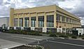
Clark House is a very old and important historic home in Hobsonville. Rice Owen Clark II built it. Later, the Royal New Zealand Air Force used it.
The Hobsonville Church & Settlers' Cemetery is another historic site. It includes a church and a cemetery. John Danby built the church on land given by Rice Owen Clark. Many of the first settlers and their families are buried in the cemetery.
.jpg)
Limeburners Bay is a significant historical place where much of Hobsonville's pottery was made. A small part of its shoreline is now a protected reserve.
Clarks Lane is a small lane in Hobsonville that is considered a historic area by Auckland Council. It once had 11 buildings for pottery workers. Today, only five small cottages and one larger house remain. The old Brigham Creek Church was also moved here to make way for a road upgrade.
The Three Unit House, also called the Boarding and Engineer's House, is a historic building on Clarks Road. It was built using the same hollow ceramic blocks as Clark House. This house was used to provide housing for workers at Clark's pottery factory.
Clark Cottage was built for Thomas Edwin Clark. It was also made with hollow ceramic blocks and recently had a nine-month renovation.
The GRP building was used by the Air Force to fix engines and other parts.
The seaplane slipway was built between 1928 and 1930. It was a ramp used to launch and retrieve seaplanes from the water.
The Sunderland Hangar was built for Tasman Empire Airways Limited, which launched seaplanes from Hobsonville.
Sunderland Avenue is where junior officers and their families lived. Their homes were built around 1937 in a style similar to English cottages.
Mill House was built for Doug Mill, who ran an aerial surveying business from Hobsonville.
The Headquarters building is an art deco style building with a parade ground nearby.
The No 4 Hangar was used to store Wasp helicopters. Today, it is used for shipbuilding.
The married officer houses are four homes on Marlborough Crescent. Built between 1925 and 1936, one is a bungalow style, and the other three are English Cottage style.
What Can You Do in Hobsonville?
A public walkway runs along much of Hobsonville's shore, perfect for walks.
The Hobsonville Marina is the local marina. It used to be called Westpark Marina. Many people, almost 100, live on about 80 of the boats docked there.
2012 Tornado Event
In December 2012, a tornado hit Hobsonville. Sadly, three construction workers building the Hobsonville Point Secondary School were killed. The tornado also damaged about 150 homes. It tore off roofs from houses in the RNZAF housing area.
Images for kids
-
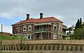
Clark House has strong ties to Hobsonville through its use in the pottery industry and as an Air Force building
-
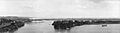
Photo from 1912 showing Greenhithe (left), Herald Island (front right), and Hobsonville (back right)
-
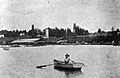
Limeburners Bay pottery works in 1905. Clark House can be seen in background
-
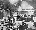
Pottery moulders working at Clark's pottery works
-
1 Technical Training School's hangar, Hobsonville
-
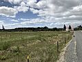
Photo taken on Clark Road showing the difference between October 2017 (left) and May 2022 (right) with the Hobsonville Church barely visible in the right photo
-
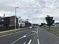
Photo taken on Clark Road showing the difference between October 2017 (left) and May 2022 (right) with the Hobsonville Church barely visible in the right photo
-

The Hobsonville ferry terminal at Launch Bay
-
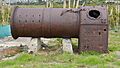
An old boiler used in pottery production at Limeburners Bay
