Hodge Beck facts for kids
Quick facts for kids Hodge Beck |
|
|---|---|

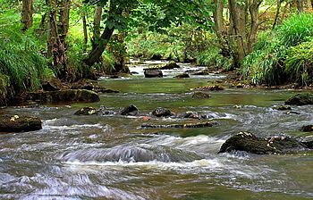
Hodge Beck in Kirkdale
|
|
|
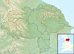
Location of the mouth within North Yorkshire
|
|
| Country | England |
| Counties | North Yorkshire |
| Physical characteristics | |
| River mouth | River Dove 54°14′18″N 0°55′51″W / 54.2384°N 0.9309°W |
| Length | 23 km (14 mi) |
| Basin features | |
| Basin size | 58 km2 (22 sq mi) |
Hodge Beck is a stream that flows through the beautiful North York Moors National Park in North Yorkshire, England. It is about 23 kilometers (14 miles) long. This stream is a branch, or tributary, of the River Dove. It joins the River Dove near a place called Welburn, which is south of Kirkbymoorside. The area of land that drains water into Hodge Beck is about 58 square kilometers (22 square miles).
Where Hodge Beck Flows
Hodge Beck starts high up on a hill called Round Hill in the Cleveland Hills. These hills are part of the North York Moors. From there, the stream flows south through a valley called Bransdale.
It then reaches a place called Cockayne. Here, another small stream, Bloworth Slack, joins it. Hodge Beck continues flowing south. It meets another tributary called Ouse Gill.
The beck then flows through Sleightholme Dale and Kirkdale. In Kirkdale, a small road crosses the stream. Sometimes, in the summer, the beck can dry up here. This happens because the water disappears into the soft limestone rock underground.
Near the Kirkdale crossing, there is a famous place called Kirkdale Cave. Many years ago, scientists found very old animal bones here. These were from huge animals that lived a long, long time ago, like mammoths and rhinos!
After leaving Kirkdale, Hodge Beck goes under the A170 bridge. It also passes an older bridge called Tilehouse Bridge, near Welburn Hall. Finally, it flows past the Slingsby Aviation airstrip before joining the River Dove.
How We Measure the Water Flow
Scientists have been measuring how much water flows in Hodge Beck since 1936. This helps them understand the stream better.
There used to be a measuring station in Bransdale. It recorded an average flow of 0.35 cubic meters per second. This station closed in the 1970s.
A new measuring station was set up at Cherry Farm in Sleightholme Dale in 1974. This station measures the water from an area of 37 square kilometers (14 square miles). It shows that the stream has an average flow of 0.67 cubic meters per second.
Hodge Beck flows naturally. This means people have not built dams or changed its flow much. The highest water level ever recorded at the Cherry Farm station was on June 19, 2005. The water was 2.55 meters (8 feet 4 inches) high! At that time, the estimated flow was 80 cubic meters per second.
The area that feeds water into the stream gets about 947 millimeters (37 inches) of rain each year. The highest point in this area is Round Hill, where the beck starts, at 451 meters (1,480 feet) high. Most of the land around the beck is moorland (open, wild land) and grassland, with some areas of woodland.
 | James Van Der Zee |
 | Alma Thomas |
 | Ellis Wilson |
 | Margaret Taylor-Burroughs |


