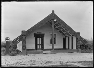
Horohoro, New Zealand facts for kids
Horohoro is a small farming community in New Zealand. It is about 15 kilometres (9.3 miles) southwest of Rotorua. Horohoro is also the name of a special flat-topped mountain. This mountain has steep cliffs and stands out in the Rotorua area. It is connected to the Horohoro Fault and Kapenga Caldera geologically.
Horohoro is the traditional home of the Ngāti Kea Ngāti Tuarā people. They have an old story about the mountain. A chief named Kahumatamomoe from the Te Arawa tribe once washed his hands in a stream there. Because of this story, the mountain's full name is Te Horohoroinga-o-ngā-ringa-o-Kahumatamomoe. This means "Washing of Kahumatamomoe's hands".
Developing the Land
In 1929, a special project started to build farms on Māori land. Āpirana Ngata, an important leader, led this project. Horohoro was one of the first places chosen for this plan. Many people moved there to help create these new farms.
Marae: Meeting Places
A marae is a very important meeting place for Māori people. Horohoro has two marae that belong to the Ngāti Kea Ngāti Tuarā people:
- Kearoa Marae
- Rongomaipapa Marae
Rongomaipapa Marae is also connected to the Tūhourangi and Ngāti Kahungunu tribes.
Education in Horohoro
Horohoro School is a public primary school. It teaches students from Year 1 to Year 8. As of February 2024, the school has a roll of 44 students.
See also
 In Spanish: Horohoro (Nueva Zelanda) para niños
 | James Van Der Zee |
 | Alma Thomas |
 | Ellis Wilson |
 | Margaret Taylor-Burroughs |


