Horseshoe Island (Antarctica) facts for kids

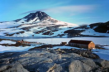
Base Y (Marguerite Bay) on Horseshoe Island with Mount Searle in the background
|
|
|
Location in Antarctica
|
|
| Geography | |
|---|---|
| Location | Antarctica |
| Coordinates | 67°51′S 67°12′W / 67.850°S 67.200°W |
| Administration | |
| Administered under the Antarctic Treaty System | |
Horseshoe Island is a cool island in Antarctica. It's about 12 kilometers (7.5 miles) long and 5.5 kilometers (3.4 miles) wide. You can find it at the entrance to Square Bay. This bay is located along the west coast of Graham Land.
The island was found and named by a group called the British Graham Land Expedition. This expedition was led by John Rymill. They explored the area by land and from the air in 1936–37. The island got its name because its mountains are shaped like a crescent, just like a horseshoe! These peaks are quite tall, ranging from 600 to 900 meters (about 2,000 to 3,000 feet) high.
Station Y: A Historic Base
At the northwest end of Horseshoe Island, there's a place called Station Y. It's also known as Horseshoe Base. This was once a British research station. It's not used anymore, but it looks almost exactly as it did in the late 1950s. All its equipment is still there!
Station Y also includes a nearby mountain hut called 'Blaiklock'. This hut was used as a shelter. Because Station Y is so well-preserved, it has been named a Historic Site or Monument (HSM 63). This special status was suggested by the United Kingdom. It was approved by the Antarctic Treaty Consultative Meeting. This means it's protected and important for history.
See also
 In Spanish: Isla Herradura para niños
 | William M. Jackson |
 | Juan E. Gilbert |
 | Neil deGrasse Tyson |


