
Image: 17th century Spanish routes to Petén flat

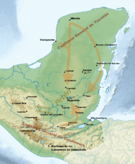
Description: Routes of approach by the Spanish against the fiercely independent Itza and their neighbours during the 17th century. For layer data see File:17th century Spanish routes to Petén.xcf Sources: The Conquest of the Last Maya Kingdom by Grant D. Jones 1998. ISBN 0-8047-3522-0. La Conquista del Lacandón by Nuria Pons Sáez 1997. ISBN 968-36-6150-5. ITMB Publishing Ltd. (1998). Guatemala (Map). 1:500000. International Travel Maps (3rd ed.) ISBN 0-921463-64-2. ITMB Publishing Ltd. (2000). México South East (Map). 1:1000000. International Travel Maps (2nd ed.) ISBN 0921463227.
Title: 17th century Spanish routes to Petén flat
Credit: File:Maya civilization location map-blank.svg
Author: File:Maya civilization location map-blank.svg: Sémhur derivative work: Simon Burchell (talk)
Usage Terms: Creative Commons Attribution-Share Alike 3.0
License: CC BY-SA 3.0
License Link: https://creativecommons.org/licenses/by-sa/3.0
Attribution Required?: Yes
Image usage
The following 3 pages link to this image:
