
Image: Achaemenid Europe

Size of this preview: 624 × 600 pixels. Other resolutions: 250 × 240 pixels | 780 × 750 pixels.
Original image (780 × 750 pixels, file size: 394 KB, MIME type: image/png)
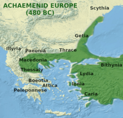
Description: Map depicting the approximate extent of Achaemenid influence in the Balkans at the outset of the Greco-Persian war of 480 BC. Based on Achaemenid Empire cylindrical projection.jpg
Title: Achaemenid Europe
Credit: Own work
Author: LeGabrie
Usage Terms: Creative Commons Attribution-Share Alike 4.0
License: CC BY-SA 4.0
License Link: https://creativecommons.org/licenses/by-sa/4.0
Attribution Required?: Yes
Image usage
The following 2 pages link to this image:

All content from Kiddle encyclopedia articles (including the article images and facts) can be freely used under Attribution-ShareAlike license, unless stated otherwise.