
Image: Borneo Topography

Size of this preview: 567 × 600 pixels. Other resolutions: 227 × 240 pixels | 1,725 × 1,824 pixels.
Original image (1,725 × 1,824 pixels, file size: 2.52 MB, MIME type: image/png)
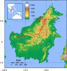
Description: Relief (hypsometric) map of Borneo. Red lines represent national borders between Indonesia (south), Malaysia (north), and Brunei (top north). Created with GMT from publicly released GLOBE data[1]. For locator version, see Image:Borneo Locator Topography.png.
Title: Borneo Topography
Credit: Own work
Author: Sadalmelik
Usage Terms: Public domain
License: Public domain
Attribution Required?: No
Image usage
The following 2 pages link to this image:

All content from Kiddle encyclopedia articles (including the article images and facts) can be freely used under Attribution-ShareAlike license, unless stated otherwise.