
Image: Carte Skagerrak-Kattegat2
No higher resolution available.
Carte_Skagerrak-Kattegat2.png (445 × 508 pixels, file size: 15 KB, MIME type: image/png)
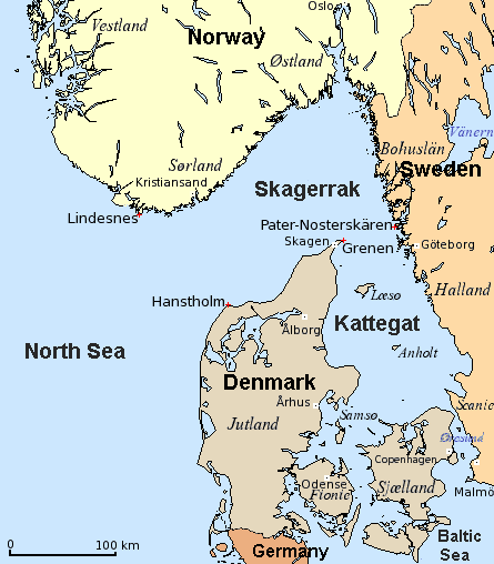
Description: Map of Skagerrak and Kattegat — straits/bays of the North Sea, along Denmark, Norway, and Sweden. The Baltic Sea drains into the Atlantic Ocean through them. Credits Scandinavian place names set by Hallvard Straume. (Mercator-projection, data from 2005.)
Title: Carte Skagerrak-Kattegat2
Credit: Modification of
Author: The original uploader was Attilios at English Wikipedia
Usage Terms: Creative Commons Attribution-Share Alike 3.0
License: CC-BY-SA-3.0
License Link: http://creativecommons.org/licenses/by-sa/3.0/
Attribution Required?: Yes
Image usage
The following 6 pages link to this image:

All content from Kiddle encyclopedia articles (including the article images and facts) can be freely used under Attribution-ShareAlike license, unless stated otherwise.