
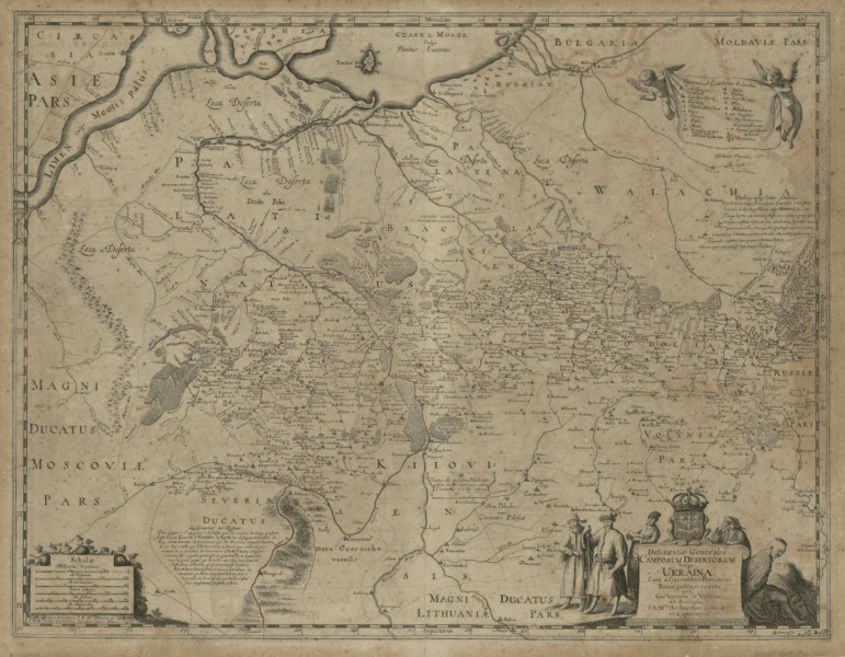
Image: General Depiction of the Empty Plains (in Common Parlance, the Ukraine) Together with its Neighboring Provinces WDL79

Description: Guillaume Le Vasseur de Beauplan was a French engineer who worked in Poland between 1630 and 1647. He built fortifications in Ukraine, most of which was then under Polish control, took part in battles with the Cossacks and Tatars, and in 1639 traveled by boat down the Dnieper (Dnipro, in Ukrainian) River. Beauplan produced two important early maps of Ukraine that were based on his own observations and his own careful astronomical and topographic measurements. His map of 1648, shown here, includes detailed information about the border areas, including Tatar routes and forts. The map is oriented with south at the top, a characteristic feature of military maps in countries exposed to attack from the south. The map was engraved by Willem Hondius, the youngest member of the distinguished family of Flemish engravers. In 1651 Beauplan also published, in French, Description d'Ukranie (Description of Ukraine), an important primary source for information about Ukraine in the 17th century.
Title: General Depiction of the Empty Plains (in Common Parlance, the Ukraine) Together with its Neighboring Provinces
Credit: Updated larger version: https://www.loc.gov/resource/g7100.ct000383/ (U.S. Library of Congress) Original: http://dl.wdl.org/79.png Gallery: http://www.wdl.org/en/item/79/
Author: Beauplan, Guillaume Le Vasseur (Died 1670)
Usage Terms: Public domain
License: Public domain
Attribution Required?: No
Image usage
The following 2 pages link to this image:

_Together_with_its_Neighboring_Provinces_WDL79.png)