
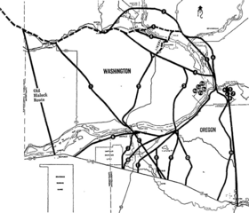
Image: Interstate 82 and Interstate 182 routing options - Tri-City Herald, March 10, 1974

Description: A 1974 map of routing options considered in prior years for Interstate 82 and Interstate 182 between the Yakima Valley and Interstate 80N (now I-84) in northeastern Oregon.
Title: Interstate 82 and Interstate 182 routing options - Tri-City Herald, March 10, 1974
Credit: "Compromise route ends 10-year interstate squabble" (sec. 14, p. 54) - Tri-City Herald
Author: Tri-City Herald
Permission: This work is in the public domain in the United States because it was published in the United States between 1927 and 1977, inclusive, without a copyright notice. For further explanation, see Commons:Hirtle chart as well as a detailed definition of "publication" for public art. Note that it may still be copyrighted in jurisdictions that do not apply the rule of the shorter term for US works (depending on the date of the author's death), such as Canada (50 p.m.a.), Mainland China (50 p.m.a., not Hong Kong or Macao), Germany (70 p.m.a.), Mexico (100 p.m.a.), Switzerland (70 p.m.a.), and other countries with individual treaties.
Usage Terms: Public domain
License: Public domain
Attribution Required?: No
Image usage
The following 2 pages link to this image:
