
Interstate 82 facts for kids
Quick facts for kids
|
|||||||
|---|---|---|---|---|---|---|---|
|
Lua error in Module:MapframeForObjects at line 258: attempt to index field 'wikibase' (a nil value).
Map of Washington and Oregon with I-82 highlighted in red
|
|||||||
| Route information | |||||||
| Length | 143.58 mi (231.07 km) | ||||||
| Existed | October 17, 1957–present | ||||||
| History | Completed in 1988 | ||||||
| Major junctions | |||||||
| West end | |||||||
|
|||||||
| East end | |||||||
| Location | |||||||
| States: | Washington, Oregon | ||||||
| Counties: | WA: Kittitas, Yakima, Benton OR: Umatilla |
||||||
| Highway system | |||||||
| Main route of the Interstate Highway System Main • Auxiliary • Business
|
|||||||

Interstate 82 (I-82) is a long highway in the states of Washington and Oregon. It stretches for about 143.58 miles (231.07 km). The road starts in Ellensburg, Washington, where it connects with Interstate 90 and U.S. Route 97.
From there, I-82 travels southeast through cities like Yakima, Washington and the Tri-Cities area in Washington. It then goes into Umatilla, Oregon. The highway finally ends near Hermiston, Oregon, connecting with Interstate 84.
I-82 is a bit special because of its number. Usually, Interstate highways with even numbers go east-west. Also, numbers increase from south to north. I-82 is north of Interstate 84, which seems to break this rule. This happened because I-84 used to be called Interstate 80N. When it was renamed in 1980, I-82 ended up north of I-84. This change was part of a plan to remove letters from Interstate numbers.
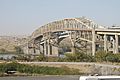
The highway crosses over Selah Creek on a special bridge. This bridge is called the Fred G. Redmon Bridge. When it opened on November 2, 1971, it was the longest concrete arch bridge in North America. The bridge is 549 feet (167 meters) long where it crosses the creek. Even though its number ends in a "2," which usually means an east-west road, I-82 mostly runs north and south.
In 1999, Oregon wanted to make Interstate 82 even longer. They looked at three different plans for new roads. However, none of these plans were chosen. I-82 also has a shorter connecting road, called a spur route. This route is Interstate 182. It links I-82 to the cities of Richland, Washington and Pasco, Washington.
Contents
Major Road Connections
Interstate 82 connects with several important roads along its path. These connections help people travel to different cities and areas.
Washington State Connections

 Interstate 90 and U.S. Route 97 in Ellensburg, Washington
 U.S. Route 12 in Yakima, Washington
 Washington State Route 24 in Yakima, Washington
- U.S. Route 97 in Yakima, Washington
 Interstate 182 and U.S. Route 12 near Richland, Washington
 U.S. Route 395 near Kennewick, Washington
Oregon State Connections
 U.S. Route 395 and U.S. Route 730 in Umatilla, Oregon
 Interstate 84 and U.S. Route 30 near Hermiston, Oregon
Cities and Towns Along the Highway
I-82 passes through or near several cities and towns. These places are important stops along the route.
- Ellensburg, Washington
- Selah, Washington
- Yakima, Washington
- Union Gap, Washington
- Zillah, Washington
- Granger, Washington
- Sunnyside, Washington
- Grandview, Washington
- Prosser, Washington
- Benton City, Washington
- Umatilla, Oregon
Counties Along the Highway
The highway crosses through different counties in both Washington and Oregon.
- Kittitas County, Washington
- Yakima County, Washington
- Benton County, Washington
- Umatilla County, Oregon
Images for kids
-
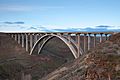
The Fred G. Redmon Bridge carries I-82 over Selah Creek in the Manastash Ridge
-
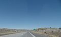
I-82 westbound near Umatilla, approaching a junction with US 395 and US 730
-
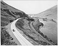
A section of the concrete-paved Yakima River Canyon Highway (now SR 821), seen shortly after opening in 1924
-
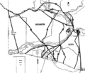
A map produced by the Tri-City Herald in 1974 showing routes considered for I-82 and later I-182
-
The original Umatilla Bridge, which now carries the eastbound lanes of I-82, seen from the Oregon side


