Union Gap, Washington facts for kids
Quick facts for kids
Union Gap, Washington
|
|
|---|---|
| Motto(s):
The old town with new ideas
|
|

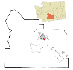
Location of Union Gap, Washington
|
|
| Country | United States |
| State | Washington |
| County | Yakima |
| Incorporated | November 23, 1883 |
| Area | |
| • City | 5.58 sq mi (14.46 km2) |
| • Land | 5.58 sq mi (14.44 km2) |
| • Water | 0.01 sq mi (0.01 km2) |
| Elevation | 984 ft (300 m) |
| Population
(2020)
|
|
| • City | 6,568 |
| • Estimate
(2023)
|
6,439 |
| • Density | 1,154.62/sq mi (445.81/km2) |
| • Urban | 133,145 |
| • Metro | 256,643 (US: 193rd) |
| Time zone | UTC−8 (Pacific (PST)) |
| • Summer (DST) | UTC−7 (PDT) |
| ZIP Codes |
98901, 98903
|
| Area code | 509 |
| FIPS code | 53-73290 |
| GNIS feature ID | 1512750 |
Union Gap is a city located in Yakima County, Washington, in the United States. In 2020, about 6,568 people lived there. Union Gap is known as a big shopping area for the Yakima Valley because of places like the Valley Mall and other busy stores. Part of the city is also connected to the Yakama Nation.
Contents
What's in a Name?
Union Gap gets its name from a special opening in the land. This opening, called a water gap, was made by the Yakima River. It's located between the Rattlesnake Hills and Ahtanum Ridge. Important roads like U.S. Route 97 and Interstate 82 pass through this gap.
A Look Back in Time: Union Gap's History
The city of Union Gap was first called Yakima City. It officially became a city on November 23, 1883.
Moving the Town
In December 1884, the Northern Pacific Railroad decided to build its tracks a little further away. Because of this, over 100 buildings from Yakima City were moved. People used rollers and horse teams to move the buildings to the new spot near the train depot.
The new town was then called North Yakima. Later, in 1918, North Yakima was renamed simply Yakima. To avoid confusion, the original town to the south was given the name Union Gap.
Where is Union Gap?
Union Gap is located at 46°33′26.46″N 120°28′30.23″W / 46.5573500°N 120.4750639°W.
Size of the City
According to the United States Census Bureau, Union Gap covers a total area of about 5.58 square miles (14.46 square kilometers). Almost all of this area is land. Only a very small part, about 0.01 square miles (0.01 square kilometers), is water.
Economy: What People Do There
Union Gap is home to some interesting businesses. For example, Liberty Bottleworks, a company that makes water bottles, has a factory there. This factory provides jobs for 18 people in the city.
Who Lives in Union Gap?
| Historical population | |||
|---|---|---|---|
| Census | Pop. | %± | |
| 1880 | 267 | — | |
| 1890 | 196 | −26.6% | |
| 1900 | 287 | 46.4% | |
| 1910 | 263 | −8.4% | |
| 1920 | 332 | 26.2% | |
| 1930 | 586 | 76.5% | |
| 1940 | 976 | 66.6% | |
| 1950 | 1,766 | 80.9% | |
| 1960 | 2,100 | 18.9% | |
| 1970 | 2,040 | −2.9% | |
| 1980 | 3,184 | 56.1% | |
| 1990 | 3,120 | −2.0% | |
| 2000 | 5,621 | 80.2% | |
| 2010 | 6,047 | 7.6% | |
| 2020 | 6,568 | 8.6% | |
| 2023 (est.) | 6,439 | 6.5% | |
| U.S. Decennial Census 2020 Census |
|||
Population in 2020
In 2020, the city of Union Gap had 6,568 people living there. There were 2,183 households and 1,527 families. The population density was about 1,177.7 people per square mile.
About 28.5% of the people were under 18 years old. About 8.7% were under 5 years old. And 10.5% of the residents were 65 years old or older.
Population in 2010
In 2010, Union Gap had 6,047 people. There were 2,061 households. About 40.3% of these households had children under 18 living with them.
The average age in the city was 32.7 years. About 28.9% of residents were under 18. Also, 10.7% were between 18 and 24 years old.
Famous Connections
Union Gap is the name behind the popular pop music group from the late 1960s, Gary Puckett & The Union Gap. The band's singer, Gary Puckett, grew up in the nearby city of Yakima.
See also
 In Spanish: Union Gap (Washington) para niños
 | Isaac Myers |
 | D. Hamilton Jackson |
 | A. Philip Randolph |

