
Rattlesnake Hills facts for kids
Quick facts for kids Rattlesnake Hills |
|
|---|---|

Rattlesnake Hills behind a vineyard.
|
|
| Highest point | |
| Peak | Lookout Summit |
| Elevation | 3,629 ft (1,106 m) |
| Geography | |
| Country | United States |
| Range coordinates | 46°27′N 119°50′W / 46.450°N 119.833°W |
The Rattlesnake Hills, also called Rattlesnake Ridge, is a long mountain ridge in Washington state. It stretches about 16 miles (26 km) through Yakima County and Benton County. This ridge is an anticline, which means it's a fold in the Earth's crust that looks like a giant hump.
It's important not to mix up the Rattlesnake Hills with a much smaller ridge also called Rattlesnake Ridge. That one is found near the Ahtanum Ridge. The highest point in the Rattlesnake Hills is Lookout Summit, which is 3,629 feet (1,106 meters) tall. This peak is also the highest point in Benton County. It is even taller than the more famous Rattlesnake Mountain by about 100 feet (30 meters).
The Rattlesnake Hills are part of the Yakima Fold Belt. This area has many long ridges that formed when ancient lava flows, called Columbia River basalt, were pushed up and folded. This happened millions of years ago during the Miocene epoch.
The Rattlesnake Hills create the northern edge of the Yakima Valley. They stretch from near Benton City to just south of the city of Yakima. The Yakima River cuts through the ridge at a place called Union Gap. West of the Yakima River, this same ridge is known as Ahtanum Ridge.
To the north of the Rattlesnake Hills, you'll find the Moxee Valley and the Black Rock Valley. Parts of the hills also reach into the Hanford Site. A smaller part of the ridge on its north side almost connects with the western end of Yakima Ridge.
The Roza Canal, which helps bring water for farming, goes under the Rattlesnake Hills through a tunnel. Some of the well-known high points in the Rattlesnake Hills include Elephant Mountain, Zillah Peak, Eagle Peak, High Top, Lookout, and Rattlesnake Mountain. These names were given by the USGS, a science agency.
The 2018 Rattlesnake Ridge Landslide
In 2018, a large, slow-moving landslide began in the Rattlesnake Hills. This event happened about 3 miles south of Yakima in Washington, USA. News about the landslide first came out in late 2017. That's when a very long crack, or fissure, was found high up on Rattlesnake Ridge. In some places, this crack was reported to be 250 feet deep!
For safety, the first road closure happened on December 17, 2017. The Washington State Department of Natural Resources created a special webpage to share information about the landslide. They reported that a huge amount of rock, about 4 million tons, was moving. This moving rock covered an area of about 20 acres. It was slowly sliding south at a speed of about 1.5 feet each week.
Around January 20–21, 2018, more news reports came out. Experts agreed that the landslide might suddenly collapse at some point. They thought this could happen within months or even weeks. Scientists continue to watch the area closely.
Images for kids
-
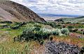
Vegetation on the north side of Rattlesnake Ridge, inside the Hanford Reach National Monument in Benton County, Washington.

