Yakima Fold Belt facts for kids
Quick facts for kids Yakima Fold Belt |
|
|---|---|
| Yakima fold-and-thrust belt | |
| Location | South-western part of Columbia Basin (Yakima, Kittitas, Klickitat, Benton, and Grant counties) |
| Coordinates | 46°24′N 120°30′W / 46.4°N 120.5°W |
| Geology | Fold and thrust belt |
The Yakima Fold Belt is an area in south-central Washington. It has many "wrinkles" or folds in the Earth's surface. These folds were created by the Earth's plates pushing together.
This area covers about 14,000 square kilometers (5,400 sq mi). It is part of the western Columbia Plateau. The folds are connected to faults (cracks in the Earth's crust). These faults have an earthquake risk. This risk is important for the Hanford Site (a nuclear facility) and for big dams on the Columbia and Snake Rivers.
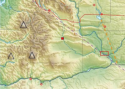
Where is the Yakima Fold Belt?

The Yakima Folds look special because they formed in layers of lava flows. These lava flows and other sediments filled in the Columbia Basin. This made the land surface smooth.
These lava flows did not go past the rising Cascade Mountains to the west and north. They also stopped at the Wenatchee Mountains. The folds themselves do not go as far east as the lava flows.
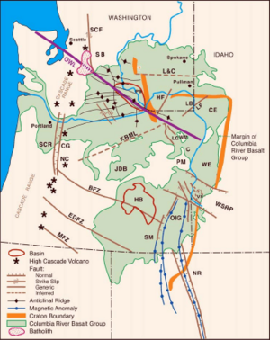
Some folds, like the Frenchman Hills, end at the Potholes Reservoir. Others, like the Saddle Mountains, stop near Othello. South of the Tri-Cities, the Horse Heaven Hills also end near the Columbia River. These ends show where a strong piece of the Earth's crust, called the North American craton, resisted the squeezing forces that made the folds.
The Columbia Hills are the southernmost ridge of the Yakima Fold Belt. They are on the north side of the Columbia River. The folding pattern continues south into Oregon. It includes the Dalles-Umatilla Syncline and the Blue Mountains anticline.
The Yakima Fold Belt is also located along the Olympic-Wallowa Lineament (OWL). This is a wide area of long, straight land features. It stretches from the Olympic Peninsula in Washington to the Wallowa Mountains in Oregon. The OWL influenced how some of the folds are shaped and spaced.
How the Yakima Fold Belt Formed
The Yakima Fold Belt is the middle part of the Olympic-Wallowa Lineament. This area is called the Cle Elum-Wallula deformed zone (CLEW). It has many narrow, uneven ridges called anticlines. It also has wide valleys called synclines.
These features formed from the folding of Miocene Columbia River basalt lava flows and sediments. Most of the folds lean towards the north. The steep side of these folds often has thrust faults. These are places where one block of rock slides over another. The folds can be from 1 km (0.6 mi) to 100 km (62 mi) long. The distance between the folds can be from a few kilometers to 20 km (12 mi).
A graben (a sunken block of Earth's crust) lies beneath almost the entire Yakima Fold Belt. This area has been sinking slowly since the Eocene time, and it continues to do so.
A study in 2011 found evidence that the Yakima Fold Belt is connected to active Puget Sound faults. This evidence came from aeromagnetic (magnetic field), gravity (Earth's pull), and paleoseismic (ancient earthquake) studies.
Earth's Movement in the Area
Scientists study the movement of the Earth's crust in this region. This is called geodetic study. They found that Oregon is slowly turning around a point south of Lewiston, Idaho. This turning motion squeezes the Yakima Fold Belt by about 3 millimeters (0.12 in) each year. The Washington Pacific coast is squeezed by about 7 millimeters (0.28 in) each year.
Studies of the Yakima Fold Belt's movement help scientists understand earthquake dangers. This is especially important for the Hanford Site.
 | Chris Smalls |
 | Fred Hampton |
 | Ralph Abernathy |


