Paleoseismology facts for kids
Paleoseismology is the study of very old earthquakes. Scientists do this by looking at clues left behind in geologic sediments (like sand and mud) and rocks. It helps us understand how often big earthquakes happened in the past, which then helps us figure out the risk of future earthquakes. Paleoseismology usually focuses on places where layers of sediment have built up over thousands of years, such as in swamps, lakes, river beds, and along shorelines.
Contents
How Scientists Study Old Earthquakes
Finding Active Faults
Paleoseismology studies begin by finding an active fault. An active fault is a crack in the Earth's crust that has moved recently and could cause earthquakes. Scientists often use satellite images to spot these faults. They also use other tools like ground-penetrating radar (GPR), which uses radio waves to see what's underground, and seismic reflection surveys, which use sound waves. Once a fault is found, scientists can figure out how old the fault movements are using radiocarbon dating, a method that tells them the age of ancient materials.
What Evidence Do They Look For?
Evidence of ancient earthquakes can be sorted by what kind of clue it is, where it's found, and when it happened.
- Primary evidence shows direct movement of the Earth, like bent or broken rock layers.
- Secondary evidence shows effects of the earthquake, like changes in how sediments were laid down or shifts in land height.
- Evidence can be found on the fault itself or away from the fault.
- The timing can be instantaneous (happening right when the earthquake strikes) or delayed (happening after the earthquake).
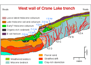
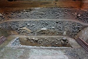
Scientists often dig trenches across faults to look at the layers of soil and rock.
- On-fault evidence includes bent layers, cracks, and wedges of broken rock that fell into cracks.
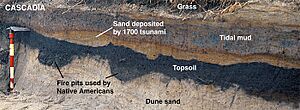
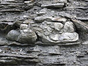
- Off-fault evidence includes sand that turned into liquid during shaking (liquefaction), layers of sand left by tsunamis, and layers of sediment called turbidites found in deep water.
Amazing Discoveries from Paleoseismology
Paleoseismology has taught us a lot about how faults behave. For example, we now know that most of the movement on a fault happens during large earthquakes. Almost all earthquakes with a magnitude over 8 (which are very powerful) leave some sign in the layers of sediment.
A great example comes from the Pacific Northwest, where the states of British Columbia, Washington, Oregon, and northern California are located. For a long time, people thought the risk of big earthquakes there was low because not many had been recorded recently. However, paleoseismology studies found clear evidence of extremely large earthquakes in the past. The most recent one happened in 1700. These studies, along with old tsunami records, showed that the subduction zone (where one of Earth's plates slides under another) in this region is very dangerous in the long term. It can cause huge coastal tsunamis that can be hundreds of feet high at the coast. When a slip happens, the coast drops, and a giant wave rushes out into the Pacific Ocean, then crashes back onto the shore.
See also
- Archaeoseismology
- Earthquake
- Earthquake magnitude
- Fault
- Historical earthquakes
- Paleotempestology
- Paleotsunami
- Seismite
- Seismology
- Tectonics
- Tsunami
- Unconformity
 | James Van Der Zee |
 | Alma Thomas |
 | Ellis Wilson |
 | Margaret Taylor-Burroughs |


