
Umatilla, Oregon facts for kids
Quick facts for kids
Umatilla, Oregon
|
|
|---|---|
|
City
|
|

Umatilla Marina, Umatilla Bridge, and McNary Dam
|
|
| Motto(s):
Catch the vision
|
|

Location in Oregon
|
|
| Country | United States |
| State | Oregon |
| County | Umatilla |
| Incorporated | 1864 |
| Area | |
| • Total | 5.08 sq mi (13.16 km2) |
| • Land | 4.99 sq mi (12.92 km2) |
| • Water | 0.10 sq mi (0.25 km2) |
| Elevation | 512 ft (156 m) |
| Population
(2020)
|
|
| • Total | 7,363 |
| • Density | 1,476.44/sq mi (570.10/km2) |
| Time zone | UTC-8 (Pacific) |
| • Summer (DST) | UTC-7 (Pacific) |
| ZIP code |
97882
|
| Area code(s) | 541 |
| FIPS code | 41-75650 |
| GNIS feature ID | 2412127 |
| Website | www.umatilla-city.org |
Umatilla is a city in Umatilla County, Oregon, United States. In 2010, about 6,906 people lived there. This number includes around 2,000 people who are in the Two Rivers Correctional Institution.
Umatilla is part of a larger area that includes the cities of Hermiston and Pendleton. The city is located on the south side of the Columbia River. It is also near U.S. Route 730 and I-82. The Umatilla Chemical Depot is about 6 miles (10 km) southwest of the city.
Contents
History

Early History and Native Peoples
For at least 10,000 years, the area where the Umatilla and Columbia rivers meet was home to the Umatilla people. They had temporary villages there. They also used the area for fishing and raising horses.
In 1806, the Lewis and Clark Expedition passed through. They wrote in their journals about a village they saw at this spot.
Founding and Growth
The first Umatilla post office opened in 1851. It was located near the Umatilla Indian Reservation. The Umatilla Indian Reservation itself was created in 1855. This happened after a treaty signed at the Walla Walla Council. Many Umatilla, Cayuse, and Walla Walla tribes moved there. Most of their lands were given to the U.S. government.
In 1862, gold was found in Idaho and Montana. This made the Columbia River a very important path to the gold fields. In the same year, Timothy K. Davenport planned a town at the mouth of the Umatilla River. He officially registered the town in 1863.
The spot was chosen because it was just below the Umatilla Rapids. These rapids made it hard for boats to travel further upstream. Goods often had to be moved from one boat to another. The town was first called Umatilla Landing, then Umatilla City, and sometimes Columbia. Its post office opened in 1863.
A Busy Trade Center
Umatilla quickly became a key center for trade. It served gold rush travelers and local farmers and ranchers. At its busiest, the town had many businesses. These included hotels, saloons, and stores.
On March 6, 1865, Umatilla became the county seat of Umatilla County. But it only held this title until 1868. The county seat then moved to Pendleton. A newspaper also started in Umatilla in 1868. For a short time in the 1860s, Umatilla competed with Wallula, Washington. Both towns wanted to be the main city of the Upper Columbia. However, the gold rush did not last long enough to support such growth.
Challenges and Rebuilding
Umatilla stayed an important business center until the late 1870s. In 1877, the rapids were removed. This allowed boats to travel directly from The Dalles to Wallula and beyond. The next year, a narrow-gauge railroad was built. It connected Umatilla to farming areas inland.
The great flood of 1894 destroyed the original business district. Many buildings that survived were moved away from the river. The Umatilla Masonic Lodge Hall, a very old building, was moved to Echo, Oregon in 1901.
By the early 1900s, Umatilla started to grow again. It became an important farming center. A new business area formed along 3rd and 4th streets. It faced the railroad tracks instead of the river. The town once again had hotels and a bank. In 1916, several women secretly ran for local office. This event is known as the Petticoat Revolution.
Umatilla Chemical Depot
The Umatilla Chemical Depot opened in 1941. It was built to help prepare for World War II. The depot stored many military items, like blankets and ammunition. In 1962, it also began storing chemical weapons.
From 1990 to 1994, the depot prepared to close. It sent all its regular ammunition to other places. On October 25, 2011, the last barrel of mustard agent was destroyed. This meant there was no longer a risk of chemical accidents from the depot in Oregon and Washington.
Town Relocation
The original town of Umatilla was completely left empty. This happened because the United States Corps of Engineers thought it would be flooded. This was due to the building of the John Day Dam. Between 1965 and 1968, the town was rebuilt south of the railroad tracks. All the old buildings were bought and torn down.
However, the relocation turned out to be unnecessary. The dam's reservoir did not affect the water level at this part of the river. Umatilla's original street layout can still be seen north of the railroad tracks. It is now a nature preserve and a protected archaeological site. It is owned by the Corps of Engineers and cannot be visited by the public.
Geography
Umatilla is about 30 miles (48 km) northwest of Pendleton.
The city covers a total area of about 4.63 square miles (11.99 km2). Of this, 4.42 square miles (11.45 km2) is land. The remaining 0.21 square miles (0.54 km2) is water.
Climate
Umatilla has a semi-arid climate. This means it is generally dry with hot summers and cool winters.
| Climate data for Umatilla | |||||||||||||
|---|---|---|---|---|---|---|---|---|---|---|---|---|---|
| Month | Jan | Feb | Mar | Apr | May | Jun | Jul | Aug | Sep | Oct | Nov | Dec | Year |
| Record high °F (°C) | 67 (19) |
78 (26) |
86 (30) |
97 (36) |
104 (40) |
110 (43) |
117 (47) |
114 (46) |
103 (39) |
89 (32) |
80 (27) |
71 (22) |
117 (47) |
| Mean daily maximum °F (°C) | 40 (4) |
47.5 (8.6) |
58.7 (14.8) |
68.6 (20.3) |
76.7 (24.8) |
83.9 (28.8) |
92.6 (33.7) |
90.5 (32.5) |
80.7 (27.1) |
67 (19) |
50.9 (10.5) |
42.1 (5.6) |
66.6 (19.2) |
| Mean daily minimum °F (°C) | 25.2 (−3.8) |
28.9 (−1.7) |
33.8 (1.0) |
40.2 (4.6) |
47 (8) |
54 (12) |
59.4 (15.2) |
57.3 (14.1) |
48.9 (9.4) |
40.1 (4.5) |
32.7 (0.4) |
28.4 (−2.0) |
41.3 (5.2) |
| Record low °F (°C) | −23 (−31) |
−23 (−31) |
10 (−12) |
20 (−7) |
26 (−3) |
32 (0) |
36 (2) |
37 (3) |
25 (−4) |
12 (−11) |
−6 (−21) |
−27 (−33) |
−27 (−33) |
| Average precipitation inches (mm) | 1.05 (27) |
0.85 (22) |
0.68 (17) |
0.55 (14) |
0.62 (16) |
0.56 (14) |
0.16 (4.1) |
0.25 (6.4) |
0.45 (11) |
0.69 (18) |
1.07 (27) |
1.09 (28) |
8.01 (203) |
| Average snowfall inches (cm) | 3.9 (9.9) |
2.1 (5.3) |
0.2 (0.51) |
0 (0) |
0 (0) |
0 (0) |
0 (0) |
0 (0) |
0 (0) |
0 (0) |
0.8 (2.0) |
1.1 (2.8) |
8.2 (21) |
| Average precipitation days (≥ 0.01 inch) | 8 | 7 | 6 | 5 | 4 | 4 | 1 | 2 | 3 | 5 | 7 | 8 | 60 |
Demographics
| Historical population | |||
|---|---|---|---|
| Census | Pop. | %± | |
| 1870 | 150 | — | |
| 1880 | 149 | −0.7% | |
| 1890 | 118 | −20.8% | |
| 1900 | 127 | 7.6% | |
| 1910 | 198 | 55.9% | |
| 1920 | 390 | 97.0% | |
| 1930 | 345 | −11.5% | |
| 1940 | 370 | 7.2% | |
| 1950 | 883 | 138.6% | |
| 1960 | 617 | −30.1% | |
| 1970 | 679 | 10.0% | |
| 1980 | 3,199 | 371.1% | |
| 1990 | 3,046 | −4.8% | |
| 2000 | 4,978 | 63.4% | |
| 2010 | 6,906 | 38.7% | |
| 2020 | 7,363 | 6.6% | |
| source: | |||
Population in 2010
In 2010, the city had 6,906 people living there. There were 1,634 households and 1,215 families. The average number of people in a household was 3.15.
About 26.1% of the people were under 18 years old. About 6.3% were 65 years or older. The average age in the city was 30.7 years. More males lived in the city (63.7%) than females (36.3%).
Economy
Umatilla's economy depends a lot on farming and related businesses. In recent years, companies like Amazon Web Services have built data centers in the city.
As of 2001, the five largest employers in Umatilla were:
- The Two Rivers Correctional Institution
- JM Manufacturing (which makes plastic pipes)
- Gilroy Food (which makes dehydrated onions)
- Boise Cascade (which makes wood chips)
- Oregon Rustic (which makes pine furniture)
Images for kids
-
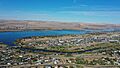
Umatilla Marina, Umatilla Bridge, and McNary Dam
-
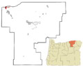
Location in Oregon
See also
 In Spanish: Umatilla (Oregón) para niños
