Echo, Oregon facts for kids
Quick facts for kids
Echo, Oregon
|
|
|---|---|

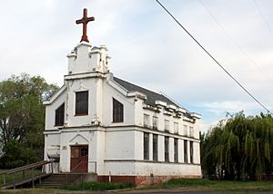
St. Peter's Catholic Church, dedicated 1913, in Echo
|
|

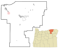
Location in Oregon
|
|
| Country | United States |
| State | Oregon |
| County | Umatilla |
| Incorporated | 1904 |
| Area | |
| • Total | 0.58 sq mi (1.50 km2) |
| • Land | 0.58 sq mi (1.50 km2) |
| • Water | 0.00 sq mi (0.00 km2) |
| Elevation | 643 ft (196 m) |
| Population
(2020)
|
|
| • Total | 632 |
| • Density | 1,093.43/sq mi (422.20/km2) |
| Time zone | UTC-8 (Pacific) |
| • Summer (DST) | UTC-7 (Pacific) |
| ZIP code |
97826
|
| Area code(s) | 458 and 541 |
| FIPS code | 41-22200 |
| GNIS feature ID | 2410394 |
| Website | www.echo-oregon.com |
Echo is a small city in Umatilla County, Oregon, in the United States. In 2020, about 632 people lived there. It is part of a larger area that includes the cities of Pendleton and Hermiston.
Contents
History of Echo, Oregon
The famous Oregon Trail used to pass just south of where Echo is today. Later, a new path called the Columbia Plateau Route opened in 1847. This new route went right through Echo, crossing the Umatilla River. This became the main path for pioneers traveling west.
Many pioneers would stop and rest at a place called Lower Crossing Camp, which was also in Echo. In the 1860s, more people started to settle in the area. They built a ferry to cross the Umatilla River at Echo. The city of Echo is named after Echo Koontz, who was the daughter of Cynthia and J. H. Koontz.
Farming was the first big reason people moved here. Crops like alfalfa and corn were very important. By 1880, a town was officially planned. A railroad was built through Echo by 1883. This made Echo an important place for shipping goods like wool, cattle, and sheep in the early 1900s. Echo officially became a city in 1904.
Geography and Climate
Echo is located in northeastern Oregon. It is about 8 miles (13 km) south of Hermiston. It is also about 20 miles (32 km) west of Pendleton. The city sits along the Umatilla River. It is about 1 mile (1.6 km) south of Interstate 84 and U.S. Route 395.
The United States Census Bureau says that Echo covers a total area of 0.58 square miles (1.50 square kilometers). All of this area is land.
Echo's Climate
Echo has a semi-arid climate. This means it is usually dry, but not a desert. It gets some rain, but not a lot.
Population and People
| Historical population | |||
|---|---|---|---|
| Census | Pop. | %± | |
| 1910 | 400 | — | |
| 1920 | 501 | 25.3% | |
| 1930 | 311 | −37.9% | |
| 1940 | 280 | −10.0% | |
| 1950 | 457 | 63.2% | |
| 1960 | 456 | −0.2% | |
| 1970 | 479 | 5.0% | |
| 1980 | 624 | 30.3% | |
| 1990 | 499 | −20.0% | |
| 2000 | 650 | 30.3% | |
| 2010 | 699 | 7.5% | |
| 2020 | 632 | −9.6% | |
| U.S. Decennial Census | |||
Echo's Population in 2010
In 2010, there were 699 people living in Echo. These people lived in 245 households. About 177 of these were families. The city had about 1205 people per square mile (465 people per square kilometer).
Most of the people in Echo were White (86.1%). Some were Native American (1.0%) or Pacific Islander (0.7%). About 9.6% were from other races. About 12.4% of the population was Hispanic or Latino.
Many households (40.8%) had children under 18 living with them. The average household had 2.85 people. The average family had 3.22 people. The median age in the city was 37.5 years old.
Parks and Recreation
Echo has some nice places for outdoor activities:
- Oregon Trail Arboretum
- Fort Henrietta Park
See also
 In Spanish: Echo (Oregón) para niños
 | Leon Lynch |
 | Milton P. Webster |
 | Ferdinand Smith |


