
Image: Mojave-sonoran deserts

Size of this preview: 379 × 600 pixels. Other resolutions: 151 × 240 pixels | 632 × 1,000 pixels.
Original image (632 × 1,000 pixels, file size: 309 KB, MIME type: image/png)
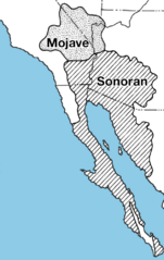
Description: Locator map of the Mojave Desert and Sonoran Desert — desert ecoregions in southwestern North America. For northwest Arizona (w:Mojave Desert), the Grand Wash Cliffs are the southwest perimeter of the high country (w:Colorado Plateau); the lower elevation lands westwards include Hualapai Valley, the w:White Hills (Arizona), and w:Detrital Valley, all bordering Lake Mead, with parts in the w:Lake Mead National Recreation Area.
Title: Mojave-sonoran deserts
Credit: http://wwwpaztcn.wr.usgs.gov/rsch_highlight/articles/200508.html
Author: USGS map
Usage Terms: Public domain
License: Public domain
Attribution Required?: No
Image usage
The following 3 pages link to this image:

All content from Kiddle encyclopedia articles (including the article images and facts) can be freely used under Attribution-ShareAlike license, unless stated otherwise.