
Image: Mosquito coast

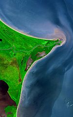
Description: Around 15 degrees North, a rounded point of land juts out into the Caribbean Sea from the Central American isthmus. This low-lying, wet area is called the Mosquito Coast, a corruption of the tribal name of some of the area’s native people, the Miskito. The area includes parts of Honduras (north) and Nicaragua (south). Between the two countries flows the Coco River, which empties into the Caribbean at Cape Gracias á Dios.
Title: Cape Gracias a Dios
Credit: http://earthobservatory.nasa.gov/Newsroom/NewImages/images.php3?img_id=17232 Transferred from the English Wikipedia en:Image:Mosquito coast.jpg
Author: NASA/GSFC/METI/ERSDAC/JAROS, and U.S./Japan ASTER Science Team
Usage Terms: Public domain
License: Public domain
Attribution Required?: No
Image usage
The following image is a duplicate of this image (more details):
The following 2 pages link to this image:
