
Image: NZ-Southland-satellite

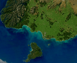
Description: View of most of the Southland Region of New Zealand's South Island, including Stewart Island (separated from the mainland by Foveaux Strait) and the southern half of Fiordland National Park. The Southland Syncline, a geological fold line, can be seen stretching from the southeast coast (at The Catlins) northwestwards through the Hokonui Hills (centre). Source=This file was derived from: Turbid Waters Surround New Zealand.jpg: Author=*Turbid_Waters_Surround_New_Zealand.jpg: Norman Kuring derivative work (a simple crop): Grutness (talk) 13:00, 16 March 2019 (UTC) Permission= Public domainPublic domainfalsefalse This image is in the public domain because it is a screenshot from NASA’s globe software World Wind using a public domain layer, such as Blue Marble, MODIS, Landsat, SRTM, USGS or GLOBE. العربيَّة | English | فارسی | français | עברית | македонски | മലയാളം | Nederlands | русский | 中文(中国大陆) | +/−
Title: NZ-Southland-satellite
Credit: derivative work (a simple crop)
Author: Aqua (satellite) MODIS
Usage Terms: Public domain
License: Public domain
Attribution Required?: No
Image usage
The following 2 pages link to this image:
