
Image: Pizzigano 1424 map (Antilia islands detail)

Size of this preview: 208 × 599 pixels. Other resolutions: 83 × 240 pixels | 331 × 954 pixels.
Original image (331 × 954 pixels, file size: 71 KB, MIME type: image/jpeg)
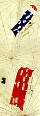
Description: Detail of north Atlantic islands in the 1424 map of w:Zuane Pizzigano, held by the Biblioteca Palatina of Parma. The islands are the four islands of the w:Antillia group. Using Pizzigano's labels, it depicts Antilia (large red rectangle), Ymana (small blue island to the west), Satanazes (large blue rectangle to the north) and Saya (umbrella-shaped red cap far north)
Title: Pizzigano 1424 map (Antilia islands detail)
Credit: Pizzigano.jpg
Author: Pizzigano.jpg: XpoferenS derivative work: Walrasiad (talk)
Usage Terms: Public domain
License: Public domain
Attribution Required?: No
Image usage
The following 3 pages link to this image:

All content from Kiddle encyclopedia articles (including the article images and facts) can be freely used under Attribution-ShareAlike license, unless stated otherwise.
.JPG)