Satanazes facts for kids
The island of Satanazes was a mysterious place that people once believed existed in the Atlantic Ocean. It was also known as the island of Devils, the Hand of Satan, or St. Athanasius. This legendary island appeared on many maps from the 1400s, even though it wasn't a real place. Such islands are called "phantom islands" because they only exist on maps or in stories.
Contents
Where was Satanazes on maps?
In the 1400s, mapmakers used special charts called portolan charts. These charts showed the island of Satanazes in the northern Atlantic Ocean. It was usually placed west of the Azores islands and Portugal. It also appeared just north of another famous legendary island called Antillia.
First appearance on maps
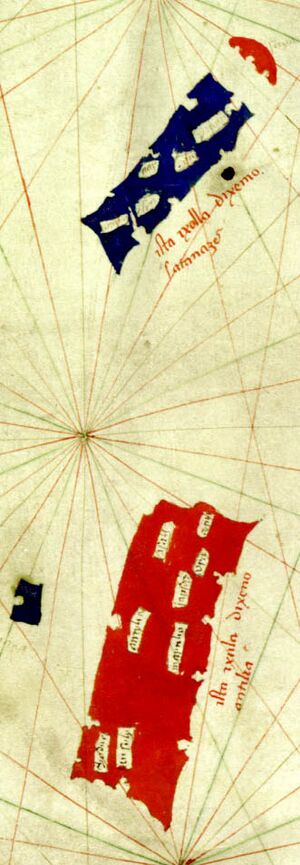
The island of Satanazes first showed up on a map in 1424. This map was made by a mapmaker from Venice named Zuane Pizzigano. He drew Satanazes as a large, blue, rectangular island. It had several bays and five or six towns marked on it.
Pizzigano wrote on the map, ista ixolla dixemo satanazes. This means "this is the island called of the devils." He placed Satanazes about 60 leagues (around 180 miles) north of the large island of Antillia.
The Antillia group
Pizzigano also drew a small, umbrella-shaped island above Satanazes. He called this island Saya. Later mapmakers would call it Tanmar or Danmar. These three islands – Satanazes, Antillia, and Saya – were often drawn together. They kept the same size, shape, and position that Pizzigano first gave them. People called them the "Antillia group" or "newly reported islands."
Other map appearances
Many other mapmakers included Satanazes on their maps:
- In 1435, Battista Beccario called it Satanagio.
- In 1436, Andrea Bianco named it Ya de la man satanaxio.
- Grazioso Benincasa showed it as Saluaga or Salvaga on his maps from 1463, 1470, and 1482.
- Other maps from the 1460s to 1489 also showed it with similar names like Salvagio or Salvagia.
However, some maps from this time did not include Satanazes. For example, the famous Nuremberg globe by Martin Behaim from 1492 left it out.
Disappearance from maps
After Christopher Columbus's voyages in the 1490s, Satanazes almost completely disappeared from maps. People think it might have been moved or changed into a smaller island. This smaller island, called the Isle of Demons, appeared between Newfoundland and Greenland on maps like the one by Johannes Ruysch in 1508.
Why was it called "Devils"?
Historians believe the name "Satanazes" comes from words meaning "satans" or "devils" in different languages. For example, Pizzigano's "Satanazes" is Portuguese for "devils."
The name changed over time. After 1436, the island started appearing as Salvaga, which means "savage." This change might have been on purpose. Mapmakers might have wanted to avoid using the word "devil."
Connection to Norse legends
Some historians think the "Devils" of Satanazes might refer to the Skrælings. These were the native peoples of Greenland and Vinland (North America). The Norse sagas, like the Saga of the Greenlanders, told stories about encounters with these people. These stories started to spread around the time Satanazes appeared on maps.
It's possible that Pizzigano drew Satanazes to show where these "devils" or "savages" were thought to live. An inscription on a 1508 map by Johannes Ruysch mentioned "devils" attacking sailors in that area. This supports the idea that the name was linked to stories of dangerous encounters.
Other theories about its meaning
Some people have suggested that the large islands of Satanazes and Antillia might have represented the coasts of North America and South America. This would mean that people might have known about the Americas before Columbus! However, this is just a theory.
Another idea is that Satanazes represented Florida, and Antillia was Cuba.
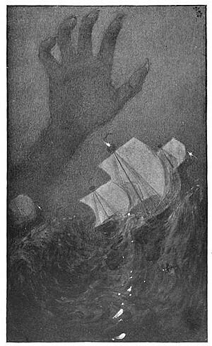
The name Ya de la man santanaxio on Andrea Bianco's 1436 map led some to call it the island of "the Hand of Satan." This name might come from an old legend from India. The story tells of a giant hand that rose from the sea every day. It would grab people and pull them into the ocean. This legend might have been known by sailors in the Atlantic. Some think this "Hand of Satan" could have been a way to describe the dangerous icebergs in the North Atlantic Ocean.
One theory from 1845 suggested that "satanaxio" actually meant S. Atanaxio, or the island of St. Athanasius. However, when Pizzigano's 1424 map was found in the 20th century, it clearly showed "Satanazes." This helped modern historians agree that it was indeed the "Isle of Devils."
Despite all these ideas, there is no single agreed-upon story for Satanazes. Unlike Antillia, which is linked to the legend of the Seven Cities, Satanazes is often called a "legendary island in need of a legend."
 | May Edward Chinn |
 | Rebecca Cole |
 | Alexa Canady |
 | Dorothy Lavinia Brown |


