Isle of Demons facts for kids
Quick facts for kids Isle of Demons |
|
|---|---|

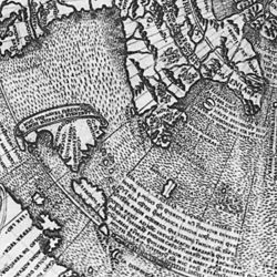
Inscription of the Isle of Demons off Newfoundland in the map. Notice Antillia further south.
|
|
| Johannes Ruysch's 1508 Map location | |
| Type | Phantom island |
| Notable locations | Quirpon Island, Newfoundland, Canada |
The Isle of Demons was a mysterious phantom island that appeared on old maps of Canada. It was thought to be near Quirpon Island in Newfoundland. People believed it was home to scary demons and wild animals. This island was often shown as two separate islands. It first appeared on maps in the early 1500s and then disappeared by the mid-1600s.
Some people think the name might have come from First Nations people. They often avoided places where someone had died, believing spirits haunted them. This could explain why many islands had similar scary names.
What Was the Isle of Demons?
People believed that the Isle of Demons was full of evil spirits and fierce beasts. These creatures were said to attack any ships that sailed by. They would also torment anyone brave enough to land on the island.
A French noblewoman named Marguerite de La Rocque was left alone on an island in the mid-1500s. This happened because she had broken rules on her ship. Some stories say the Isle of Demons was where she was abandoned. People have even claimed to see her and the young man she was with on the island.
Over many centuries, writers, poets, and singers have shared Marguerite's story. Today, experts believe the island where she was left was probably Harrington Harbour, Quebec.
Where Did the Idea Come From?
The Isle of Demons first showed up on a map made by Johannes Ruysch in 1508. It might have been a new location for an older legendary island called Satanazes. Satanazes means "Devils" in Portuguese.
In the 1400s, Satanazes was usually shown in the middle of the Atlantic Ocean. It was just north of another mythical island called Antillia. After explorers mapped the Atlantic better in the 1490s, Ruysch might have moved the old Satanazes to a new, more fitting spot.
Maps and Explorers
The Isle of Demons kept appearing on maps even after explorers like Jacques Cartier had explored much of Newfoundland. Cartier made expeditions in 1534, 1535, and 1541. He explored the Gulf of St. Lawrence and nearby areas.
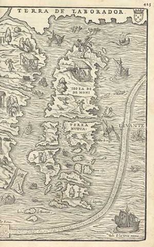
For example, the "Isola de Demoni" was shown on a 1556 map by Giacomo Gastaldi. This map was called "La Nueva Francia." Gastaldi's map showed the "Isola de Demoni" as a very large island. It seemed to cover the northern part of Newfoundland. The map even had pictures of flying demons on it!
See also
 In Spanish: Isla de los Demonios para niños
 | Mary Eliza Mahoney |
 | Susie King Taylor |
 | Ida Gray |
 | Eliza Ann Grier |


