Zuane Pizzigano facts for kids
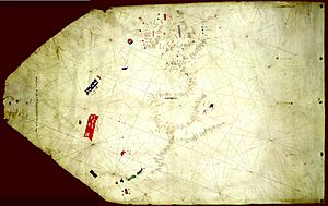
Zuane Pizzigano (also known as Giovanni Pizzigano) was a mapmaker from Venice in the 1400s. He created a famous map in 1424. This map was the first one known to show some mysterious, imaginary islands in the northern Atlantic Ocean. These islands were part of a group called the Antillia archipelago. The map showed islands like Antillia, Satanazes, Royllo, and Tanmar.
Contents
Who Was Zuane Pizzigano?
We don't know much about Zuane Pizzigano's life. He was likely related to other mapmakers from Venice, Domenico and Francesco Pizzigano. They made a well-known map in 1367. Zuane might have been their descendant.
The 1424 Pizzigano Map
Zuane Pizzigano created an important map in 1424. It is often called the "Pizzigano Map." The map is about 57 by 90 centimeters in size. It was found in 1953 among many old papers belonging to a collector named Sir Thomas Phillipps. Today, you can find this map at the James Ford Bell Library in Minneapolis, USA.
It's not completely certain who made the map. A note on the map says: "1424 on 22 August, Zuane Pizzi..... made this map." The end of the name "Pizzi" is smudged. It looks like someone tried to erase and then fix the name. When looked at with special light, it seems to show "pizzigano." Zuane is a common way to say Giovanni (which means John) in the Venetian language. Even if his name isn't perfectly clear, the date is. Other mapmakers in the 1400s copied parts of Pizzigano's work. This shows how important his map was.
What the Map Shows
The 1424 Pizzigano map is a special type of nautical (sea) map called a portolan chart. It mainly shows western Europe, northwest Africa, and a large part of the northern Atlantic Ocean. The map includes both real islands and mythical (imaginary) ones far out in the ocean. The notes on the map are written in both Venetian and Portuguese.
The map shows the Canary Islands in good detail, even though the drawing is simple. It marks eight known islands:
- Alegranza (Alegranza)
- Larozio (Roque del Este)
- Lancarot (which is Lanzarote)
- Louos (Lobos Island)
- Fortubentura/Fortouentura (Fuerteventura)
- Canaria (Gran Canaria)
- Inferno (Tenerife)
- Balmar (La Palma)
However, the map is missing La Gomera and El Hierro. These islands had been shown on earlier maps. Pizzigano also drew a large, mysterious red island south of the Canaries. It has four smaller islands around it and is called Himadoro. This might be the legendary Saint Brendan's Island.
The map also shows the Madeira Islands. These islands were officially discovered by the Portuguese between 1418 and 1420. Pizzigano's map correctly names them:
- Madera (Madeira)
- Portosanto (Porto Santo)
- Dexrexta (Desertas)
- Saluazes (Savage Islands)
This shows that information from new explorations was quickly shared among sailors and mapmakers.
Even more surprising, Pizzigano's map seems to show the Azores islands. These islands were not officially discovered by the Portuguese until 1431 (or possibly 1427 at the earliest). Some older maps, like the Catalan Atlas from 1375, had also shown Atlantic islands. Their names sometimes came from old European stories. According to a guess by a historian named Cortesão, the islands on Pizzigano's 1424 map are:
- Lubrioczo (São Jorge)
- Ixola de Uentula (Faial)
- Ixo de Braxil (Terceira)
- Capiria (São Miguel)
- Louo (Santa Maria)
The Antillia Island Group
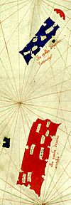
The most famous islands on Pizzigano's 1424 map are the Antillia group. These four islands are in the middle of the Atlantic Ocean, west of where the Azores might be. Pizzigano was the first known mapmaker to show them. The group has two very large, rectangular islands:
- The big red island is called Antilia (Pizzigano wrote "ista ixolla dixeno Antilia").
- About sixty leagues (a league is about 3 miles) north of Antilia is the large blue island called Satanazes (Pizzigano wrote "ista ixolla dixemo Satanazes"). Later maps called it Satanaxio or Salvagio.
West of the large Antilia is a small blue island called Ymana. Later maps called this Royllo. North of Satanazes is a red, half-circle island called Saya. Later maps called this Tanmar or Danmar.
Historians have wondered if Pizzigano's drawing of the Antillia group was based on stories of people possibly traveling across the ocean to the Americas before Columbus. But we don't know for sure. For a while, people thought he might have used a hint from a 1367 map made by the Pizzigani brothers (who were his relatives). However, that idea has now been set aside. Most experts agree that Zuane Pizzigano was the first known mapmaker to show the legendary Antillia group on a map.
The name of the main island, Antillia, probably comes from the Portuguese words ante-ilha, meaning "opposite island." This means it was an island facing Portugal. The name comes from an old story from the Iberian Peninsula (where Spain and Portugal are). The legend says that in 714, seven bishops from a group called the Visigoths fled from the Muslim conquest of Hispania. They sailed across the Atlantic with their followers to build a new home on this island. Pizzigano, like many others after him, tried to show and name the seven settlements on the island. Because of this, it is also known as the "island of Seven Cities."
The origin of Satanazes (which means "Isle of Devils" in Portuguese) is less clear. This island might be linked to stories from the Norsemen about Greenland and Vinland. These stories started to spread south around this time. The native people in these stories, called Skrælings, might have been seen as the "devils" in the island's name. The island Ymana, west of Antilia, might be a different spelling of Ynsula Mam, a legendary island first shown in 1367 by the Pizzigani brothers. The island Saya is more mysterious.
No matter where he got his information, Zuane Pizzigano mapped the Antillia island group. The number of islands, their sizes, shapes, and locations were copied almost exactly by most mapmakers throughout the 1400s. Famous mapmakers like Battista Beccario (1435), Andrea Bianco (1436), and Grazioso Benincasa (1462, 1470, 1482) all copied his work. Even the 1492 Erdapfel globe by Martin Behaim used Pizzigano's ideas.
Pizzigano's 1424 map also includes two other legendary islands:
- The three-colored circular island of Braxil is located just west of Ireland. This is believed to be the mythical island of Brasil, which had already appeared on earlier maps.
- Southwest of Brasil, about halfway to the Antillia group, is a blue, half-circle island called Ixola de Uentura. This island is near where the Pizzigani brothers first showed the legendary Isle of Mam in 1367. Zuane Pizzigano might have meant to draw that same island. However, if Uentura is Mam, then Ymana would be a separate mystery. One idea is that Ixola de Uentura is related to Illa Verde ("Green Island"), which might refer to Greenland. Stories about this island from Norse or Irish sources were sometimes shown on maps, and perhaps Iberian fishermen already knew about it.
 | Ernest Everett Just |
 | Mary Jackson |
 | Emmett Chappelle |
 | Marie Maynard Daly |


