El Hierro facts for kids
|
Nickname: Isla del Meridiano
|
|
|---|---|
 |
|
 |
|
| Geography | |
| Location | Atlantic Ocean |
| Coordinates | 27°45′N 18°00′W / 27.750°N 18.000°W |
| Archipelago | Canary Islands |
| Area | 268.51 km2 (103.67 sq mi) |
| Highest elevation | 1,501 m (4,925 ft) |
| Highest point | Pico de Malpaso |
| Administration | |
|
Spain
|
|
| Autonomous Community | Canary Islands |
| Province | Santa Cruz de Tenerife |
| Capital city | Valverde |
| Demographics | |
| Population | 11,338 (2020) |
| Pop. density | 40.8 /km2 (105.7 /sq mi) |
| Languages | Spanish, specifically Canarian Spanish |
| Additional information | |
| Time zone |
|
| • Summer (DST) | |
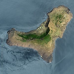
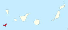
El Hierro is a special island in the Canary Islands. It's often called Isla del Meridiano (the "Meridian Island"). It's the second-smallest island in the Canaries. It's also the farthest south and west.
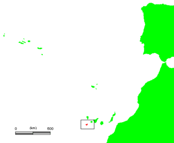
El Hierro is located in the Atlantic Ocean. It's off the coast of Africa. The island is part of Spain. Its capital city is Valverde. About 11,000 people live there. The island is about 268.51 square kilometers in size.
Contents
What's in a Name?
The name El Hierro sounds like the Spanish word for 'iron'. But it actually has nothing to do with iron! The letter 'H' in the name of the metal came from an older 'F'. This change happened a long time ago.
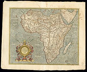
Because of this, people in other countries got confused. In the 16th century, maps and books called the island by words for 'iron'. For example, in Portuguese it was Ferro. In French, it was l'île de Fer.
The real origin of the name is a bit of a mystery. It might come from the Guanche language. This was the language of the island's first people, called Bimbaches. Some think it comes from "Esero," meaning 'strong'. Others believe it comes from "hero" or "herro." This word meant 'cistern' or 'spring' in Guanche. The Bimbaches had to build cisterns. These were like big tanks to collect fresh rainwater.
El Hierro's Past
The first people on El Hierro were the Bimbaches. They became part of Spanish rule in the 1400s. This happened mostly through talks, not fighting. A European leader named Jean de Béthencourt made a deal with the Bimbaches. He promised to respect their freedom. But his son later broke this promise. Many Bimbaches were sold into slavery.
Later, many French and Galician people settled on the island. There was a rebellion by the native people. They were unhappy with how they were treated. But the rebellion was stopped.
Island Changes: Landslides and Volcanoes
El Hierro has changed a lot over thousands of years. Huge landslides have happened here. One big landslide, called 'El Golfo', happened about 15,000 years ago. It caused a large part of the island's northern side to collapse. This created the El Golfo valley. These landslides might have caused tsunamis. But scientists haven't found clear proof of that yet.
Recent Volcanic Activity
In 2011, scientists noticed a lot of small tremors on El Hierro. This meant there was increased seismic activity. Over 4,000 tremors were recorded. This was a sign that magma was moving underground.
On October 10, 2011, a small underwater volcano began to erupt. It was about 7 kilometers south of La Restinga. The volcanic threat level was raised to "red." People living in La Restinga had to leave their homes for a while. This eruption was a surtseyan type. This means it happened underwater. After the eruption, tiny fossils of sea creatures were found.
El Hierro's Weather
The weather on El Hierro changes depending on where you are. It can be like a subtropical Mediterranean area in the middle. Near the coast, it can be semi-arid or even a desert climate. The ocean greatly affects the temperatures.
Here's a quick look at the weather at El Hierro Airport:
| Climate data for Hierro Airport | |||||||||||||
|---|---|---|---|---|---|---|---|---|---|---|---|---|---|
| Month | Jan | Feb | Mar | Apr | May | Jun | Jul | Aug | Sep | Oct | Nov | Dec | Year |
| Record high °C (°F) | 28.5 (83.3) |
29.4 (84.9) |
32.6 (90.7) |
33.2 (91.8) |
31.4 (88.5) |
32.0 (89.6) |
32.4 (90.3) |
33.8 (92.8) |
33.3 (91.9) |
34.2 (93.6) |
32.4 (90.3) |
28.3 (82.9) |
34.2 (93.6) |
| Mean daily maximum °C (°F) | 20.9 (69.6) |
20.8 (69.4) |
21.4 (70.5) |
21.6 (70.9) |
22.6 (72.7) |
24.0 (75.2) |
25.0 (77.0) |
26.1 (79.0) |
26.5 (79.7) |
25.6 (78.1) |
23.7 (74.7) |
22.2 (72.0) |
23.4 (74.1) |
| Daily mean °C (°F) | 18.8 (65.8) |
18.6 (65.5) |
19.0 (66.2) |
19.3 (66.7) |
20.3 (68.5) |
21.7 (71.1) |
22.8 (73.0) |
23.7 (74.7) |
24.1 (75.4) |
23.3 (73.9) |
21.6 (70.9) |
20.0 (68.0) |
21.1 (70.0) |
| Mean daily minimum °C (°F) | 16.6 (61.9) |
16.4 (61.5) |
16.7 (62.1) |
17.0 (62.6) |
17.9 (64.2) |
19.3 (66.7) |
20.5 (68.9) |
21.3 (70.3) |
21.7 (71.1) |
20.9 (69.6) |
19.5 (67.1) |
17.8 (64.0) |
18.8 (65.8) |
| Record low °C (°F) | 8.0 (46.4) |
9.0 (48.2) |
9.2 (48.6) |
10.0 (50.0) |
10.0 (50.0) |
10.0 (50.0) |
14.0 (57.2) |
14.2 (57.6) |
15.2 (59.4) |
11.0 (51.8) |
12.0 (53.6) |
9.6 (49.3) |
8.0 (46.4) |
| Average precipitation mm (inches) | 28 (1.1) |
29 (1.1) |
20 (0.8) |
14 (0.6) |
2 (0.1) |
1 (0.0) |
0 (0) |
0 (0) |
2 (0.1) |
12 (0.5) |
26 (1.0) |
33 (1.3) |
170 (6.7) |
| Average precipitation days (≥ 1.0 mm) | 3 | 2 | 3 | 1 | 0 | 0 | 0 | 0 | 0 | 2 | 2 | 4 | 19 |
| Average relative humidity (%) | 74 | 76 | 74 | 74 | 74 | 75 | 77 | 78 | 77 | 76 | 74 | 74 | 75 |
| Mean monthly sunshine hours | 140 | 158 | 184 | 197 | 233 | 229 | 210 | 234 | 210 | 189 | 157 | 143 | 2,339 |
| Source 1: Agencia Estatal de Meteorología (normals 1981–2010) | |||||||||||||
| Source 2: Agencia Estatal de Meteorología (extremes 1973–present) | |||||||||||||
Nature and Wildlife
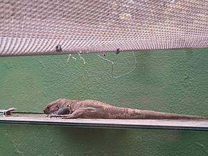
El Hierro is home to unique animals and plants. One special animal is the El Hierro giant lizard. It's a critically endangered species. There's a special program to help these lizards. They are bred in captivity and then released back into the wild.
The island gets some rain, especially in its inner parts. This helps plants grow. You can find juniper trees and pine forests. In 2000, UNESCO named El Hierro a Biosphere Reserve. This means 60% of the island is protected. This helps keep its nature and culture safe. Many kinds of cetaceans, like whales, live in the waters around the island.
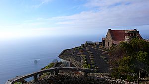
El Hierro is a volcanic island. It has many mountains. It formed about 1.2 million years ago. It has over 500 volcano cones. There are also about 70 caves and volcanic tunnels. One of these is the Cueva de Don Justo. Its tunnels stretch for over 6 kilometers. The highest point on the island is Malpaso. It is 1501 meters high.
Visiting El Hierro
El Hierro is a popular place for tourists. It has a small airport in Valverde. There's also a ferry terminal at Puerto de la Estaca. Both connect the island to Tenerife.
El Hierro has a few hotels and guesthouses. Many are small, family-run places. Because it's a UNESCO World Biosphere Reserve, new buildings are limited. This helps the island keep its traditional look. It also helps protect its natural beauty.
How El Hierro is Governed
El Hierro is part of the province of Santa Cruz de Tenerife. It has three main areas called municipalities:
| Name | Area (km2) |
Population (2019) |
|---|---|---|
| Frontera | 84.20 | 4,093 |
| El Pinar | 80.66 | 1,870 |
| Valverde | 103.65 | 5,005 |
| Totals | 268.51 | 10,968 |
Valverde is in the northeast. Frontera is in the west. Both have several smaller villages. The main government office for the island is in Valverde. About half of the island's people live there.
The "Meridian Island"
For over 500 years, El Hierro was used as the prime meridian in many parts of Europe. A prime meridian is the starting line for measuring longitude on maps. As early as the 2nd century CE, Ptolemy thought about using the westernmost known land as the zero meridian.
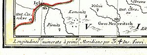
In 1634, France decided to use El Hierro's meridian as a key reference for maps. This was because it was the westernmost known land in the "Old World." Maps from that time often showed two sets of longitude numbers. One was based on Paris, and the other on El Hierro.
Festivals and Celebrations
The biggest festival on El Hierro is the Bajada de la Virgen de los Reyes. It happens every four years. It's held on the first Saturday of July. The last one was in 2017, and the next will be in 2021.
During this festival, a statue of the Virgin of the Kings is carried. She is the patron saint of El Hierro. The statue is moved from her sanctuary in La Dehesa. It is carried 44 kilometers to the capital, Valverde. It passes through all the towns on the island. The annual festival for the Virgin is also celebrated every September 24.
Island Symbols
El Hierro has official natural symbols. These are the El Hierro giant lizard (Gallotia simonyi machadoi). The other is the Sabina tree (Juniperus phoenicea).
Green Energy
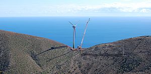
El Hierro wants to be the first island in the world to get all its electricity from its own sources. This means using only renewable energy. They are doing this with a big project. It combines a large wind farm with two hydroelectric projects.
This project is called Gorona del Viento El Hierro. It uses five large wind turbines. They can produce 11.5 megawatts of wind power. This is enough electricity for the island's residents and tourists. It also powers three water desalination plants. These plants turn seawater into fresh drinking water.
The system also stores extra wind power. It pumps water up 700 meters to a volcano crater. When there's no wind, the water is released. It flows down to a smaller basin. This generates 11.3 megawatts of electricity. When there's extra wind power again, the water is pumped back up.
This system saves a lot of money. It means the island doesn't need to import as much oil. In 2016, the power plant met 40.7% of the island's electricity needs. In 2017, it was 46.5%. In early 2018, El Hierro ran entirely on renewable energy for over 560 hours!
Bimbache openART Festival
The Bimbache openART Festival started in 2005. It's a non-profit event. It brings together artists and ideas from different fields. The festival wants to connect people and cultures. It also supports El Hierro's "Sustainable Island" program. It works with scientists and groups focused on sustainability.
El Hierro in Books
El Hierro has appeared in several books:
- In Umberto Eco's novel The Island of the Day Before. This book is about a nobleman stuck on an island near the International Date Line.
- In Christopher Isherwood's short story "The Turn Round the World."
- In the first chapter of Steven Callahan's book "Adrift." This book tells the true story of his survival at sea. El Hierro was his last stop before his boat trip across the Atlantic.
Images for kids
See also
 In Spanish: El Hierro para niños
- List of volcanoes in Spain
- Prime meridian
 | Shirley Ann Jackson |
 | Garett Morgan |
 | J. Ernest Wilkins Jr. |
 | Elijah McCoy |


