
Alegranza facts for kids

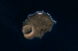
An aerial view of Alegranza
|
|

Alegranza
Location in Province of Las Palmas

Alegranza
Location in Canary Islands

Alegranza
Location in Spain, Canary Islands
|
|
| Geography | |
|---|---|
| Coordinates | 29°23′56″N 13°30′43″W / 29.399°N 13.512°W |
| Archipelago | Chinijo Archipelago |
| Area | 10.202 km2 (3.939 sq mi) |
| Highest elevation | 289 m (948 ft) |
| Administration | |
| Autonomous Community | Canary Islands |
| Province | Las Palmas |
| Municipality | Teguise |
| Demographics | |
| Population | 0 (2013) |
Alegranza (Spanish pronunciation: [aleˈɣɾanθa]) is a small, uninhabited island in the Atlantic Ocean. It is located near the coast of Africa. This island is part of the Canary Islands in Spain. Alegranza is the northernmost point of the Canary Islands. It is also part of a group of islands called the Chinijo Archipelago. The island belongs to the municipality of Teguise on Lanzarote.
Island Features
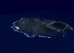
Alegranza covers an area of about 10.2 square kilometers. The island has a volcano with a large crater. This crater is about 1.1 kilometers wide. The volcano's highest point is 289 meters tall. Another high point is Montaña de Lobos, which is 256 meters high. The northern part of the island is mostly flat land.
-
NASA satellite image of Alegranza
-


Protecting Nature
Alegranza is a very important place for nature. It is part of the Chinijo Archipelago Natural Park. This park helps protect the plants and animals that live there. No people live on Alegranza.
The Punta Delgada Lighthouse is on the eastern side of Alegranza. This lighthouse was built a long time ago, between 1861 and 1865. In 2002, it was named a historic monument. This means it is a special building that needs to be protected.
A Look at History
The name Alegranza comes from a Spanish word meaning "joy." Some people say that Jean de Bethencourt gave the island this name. He was an explorer who felt joy when he first saw the land. The Jordán-Martinón family has owned the island since the 1940s.
See also
 In Spanish: Alegranza para niños
