Royllo facts for kids
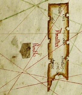
Royllo (sometimes spelled Roillo) is a mysterious, legendary island that people once believed existed in the Atlantic Ocean. It was probably the same island that was called Ymana on a very old map from 1424, made by Zuane Pizzigano.
On many maps from the 1400s, Royllo is shown as a small island. It usually appears about 20 leagues (which is about 60 miles or 97 kilometers) west of a much larger legendary island called Antillia. Royllo was often grouped with other "newly discovered islands" on these old maps, even though it might not have been real.
Contents
What Are Phantom Islands?
Phantom islands are islands that appeared on maps for a while but were later found not to exist. They might have been mistakes, optical illusions, or even stories that cartographers (mapmakers) believed were true. Royllo is a famous example of a phantom island.
Why Did Phantom Islands Appear on Maps?
In the past, exploring the oceans was very difficult and dangerous. Sailors often saw things that looked like land but were actually clouds, fog, or icebergs. Sometimes, they might have heard stories from other sailors that turned into legends. Mapmakers would then draw these islands on their maps, hoping to show new discoveries.
The Search for New Lands
During the 1400s and 1500s, European explorers were eager to find new lands and trade routes. They sailed across the Atlantic, looking for new places. Maps were very important tools for these journeys. Even if an island was a myth, its presence on a map could encourage more exploration.
Royllo's Place on Old Maps
Royllo was a common feature on many maps from the 15th century. Its consistent placement near Antillia suggests that mapmakers copied information from each other.
The Pizzigano Map of 1424
One of the earliest mentions of what might be Royllo is on Zuane Pizzigano's map from 1424. On this map, the island is called "Ymana." This map is important because it shows some of the first detailed depictions of these legendary Atlantic islands.
Grouped with "Newly Discovered Islands"
Royllo was often shown as part of a group of islands labeled insulae de novo repertae. This Latin phrase means "newly discovered islands." This label shows how exciting the idea of finding new lands was at the time. It also highlights that these islands were considered recent findings, even if they were only based on rumors or errors.
The End of Royllo's Legend
As navigation improved and more accurate maps were made, phantom islands like Royllo slowly disappeared from charts. Explorers eventually sailed through the areas where these islands were supposed to be and found nothing. This proved that many of these mysterious lands were just legends.
 | Anna J. Cooper |
 | Mary McLeod Bethune |
 | Lillie Mae Bradford |


