
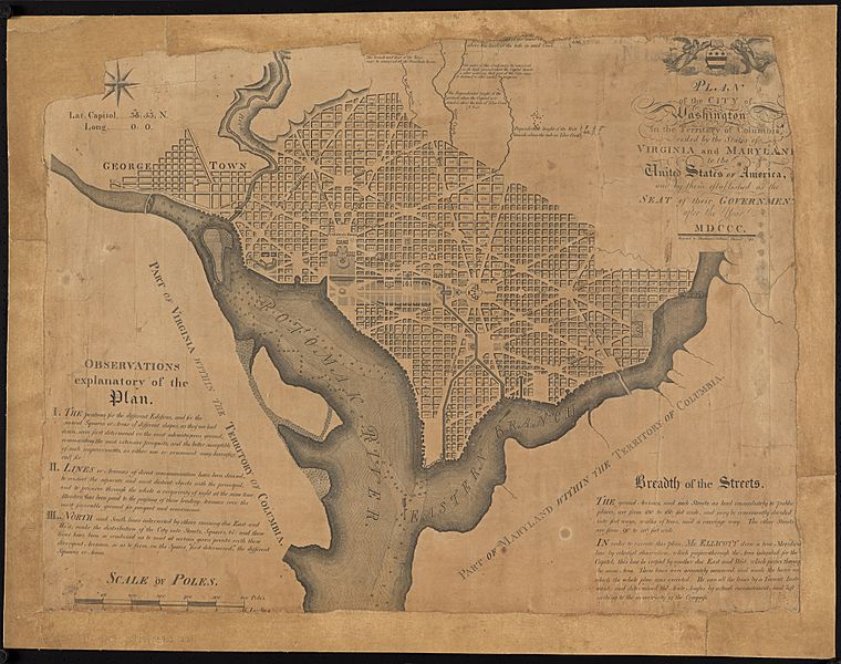
Image: Plan of the city of Washington in the territory of Columbia, ceded by the states of Virginia and Maryland to the United States of America ... (8249620373)

Description: Zoom into this map at maps.bpl.org. Author: Ellicott, Andrew Publisher: Thackera & Vallance Date: 1792 Location: Philadelphia Dimensions: 52 x 68 cm. Scale: [ca. 1:19,800] From: Norman B. Leventhal Map Center Collection at the Boston Public Library / American Revolutionary War-Era Maps (Collection of Distinction) Call Number: G3850 1792 .E45
Title: Plan of the city of Washington in the territory of Columbia, ceded by the states of Virginia and Maryland to the United States of America ... (8249620373)
Credit: Flickr: Plan of the city of Washington in the territory of Columbia, ceded by the states of Virginia and Maryland to the United States of America ..., from Norman B. Leventhal Map Center Collection at the Boston Public Library Uploaded by tm
Author: http://maps.bpl.org
Usage Terms: Creative Commons Attribution 2.0
License: CC BY 2.0
License Link: https://creativecommons.org/licenses/by/2.0
Attribution Required?: Yes
Image usage
The following 3 pages link to this image:

.jpg)