
Image: Rhins of Galloway Map

Size of this preview: 324 × 599 pixels. Other resolutions: 130 × 240 pixels | 1,206 × 2,230 pixels.
Original image (1,206 × 2,230 pixels, file size: 1.11 MB, MIME type: image/png)
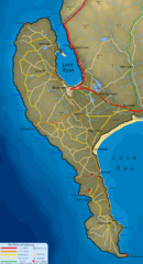
Description: Map of the Rhins of Galloway, Scotland
Title: Rhins of Galloway Map
Credit: Topo data NASA SRTM, PD. Map details (inc. roads, rail, rivers & bathometry) derived from Plate 16 of J.G. Bartholomew's 'Survey Atlas of Scotland', 1912, PD by Berne Convention.
Author: SFC9394
Permission: © SFC9394, licensed under CC-BY-SA 2.5. If using image please attribute to 'SFC9394' as required by licence.
Usage Terms: Creative Commons Attribution-Share Alike 2.5
License: CC BY-SA 2.5
License Link: https://creativecommons.org/licenses/by-sa/2.5
Attribution Required?: Yes
Image usage
The following 3 pages link to this image:

All content from Kiddle encyclopedia articles (including the article images and facts) can be freely used under Attribution-ShareAlike license, unless stated otherwise.