
Rhins facts for kids
Quick facts for kids Rhins |
|
| Reins | |
| River | |
_le_Rhins_%C3%A0_l%27H%C3%B4pital-sur-Rhins.JPG) The Rhins in Saint-Cyr-de-Favières.
|
|
| Country | |
|---|---|
| Region | Auvergne-Rhône-Alpes |
| Departments | Rhône, Loire |
| Municipalities | Amplepuis, Le Coteau, Roanne |
| Tributaries | |
| - left | Gand |
| - right | Trambouze |
| City | Roanne |
| Source | Monts du Beaujolais |
| - location | Ranchal, Rhône, France |
| - elevation | 760 m (2,493 ft) |
| - coordinates | 46°8′8″N 4°21′55″E / 46.13556°N 4.36528°E |
| Confluence | Loire |
| - location | Roanne, Loire, France |
| - elevation | 265 m (869 ft) |
| - coordinates | 46°3′3″N 4°6′33″E / 46.05083°N 4.10917°E |
| Length | 59.8 km (37 mi) |
| Basin | 468 km² (181 sq mi) |
| Discharge | for Saint-Cyr-de-Favières |
| - average | 5.17 m³/s (183 cu ft/s) |
The Rhins or Reins is a river located in central France. It flows through the Auvergne-Rhône-Alpes region. This river is a tributary, meaning it flows into a larger river. The Rhins joins the Loire, which is one of France's longest rivers.
Contents
Exploring the Rhins River
The Rhins river is about 59.8 kilometers (37.2 miles) long. It has a drainage basin that covers an area of 468 square kilometers (181 square miles). A drainage basin is the land area where water collects and drains into a specific river.
Where Does the Rhins River Start?
The Rhins river begins in the Monts du Beaujolais mountains. Its source is in a French commune (like a small town or district) called Ranchal. This area is part of the Rhône department in France. The river starts at a high point, about 760 meters (2,493 feet) above sea level.
From its source, the Rhins river first flows south. Then, it changes direction and flows west. Finally, it turns to the northwest.
Which Areas Does the Rhins River Flow Through?
The Rhins river flows through the Auvergne-Rhône-Alpes region. It passes through two different departments and 21 communes. Some of the main communes it flows through include:
- In the Rhône department: Saint-Vincent-de-Reins, Cublize, and Amplepuis.
- In the Loire department: Saint-Victor-sur-Rhins, Régny, Le Coteau, and Roanne.
The journey of the Rhins river ends when it flows into the Loire river. This meeting point is in the commune of Roanne.
Main Rivers Joining the Rhins
_confluence_Rhins-Gand_%C3%A0_l%27H%C3%B4pital-sur-Rhins.JPG)
Smaller rivers that flow into a larger river are called tributaries. The Rhins river has a few important tributaries.
Left Tributaries
- Gand: This river is 28.1 kilometers (17.5 miles) long and joins the Rhins from the left side.
Right Tributaries
- Trambouze: This river is 19.9 kilometers (12.4 miles) long and joins the Rhins from the right side.
How Much Water Does the Rhins River Carry?
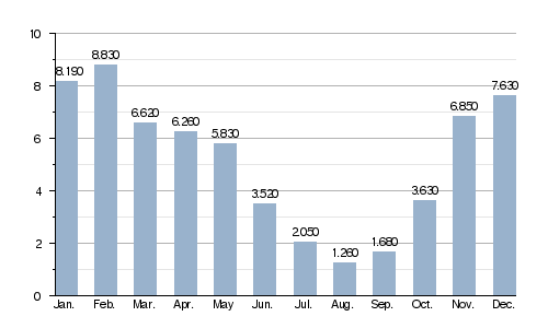
The amount of water that flows through a river at a certain point is called its discharge. The average yearly discharge of the Rhins river is about 5.17 cubic meters per second (182 cubic feet per second). This measurement was taken at Saint-Cyr-de-Favières in the Loire department, based on data from 1969 to 2017.
The Rhins is a small river, and its water levels change a lot throughout the year. These changes are called seasonal fluctuations.
Seasonal Changes in River Flow
The river usually has the most water during the winter and spring months. This period is from November to May. The highest water levels are typically seen in February.
After May, the water flow starts to decrease quickly. The period when the river has the least water is from late June to early October.
Average monthly discharge (cubic meters per second) at Saint-Cyr-de-Favières (1969 - 2017)
Related Pages
Images for kids
-
Map of the Rhinns of Galloway

