
Image: Sierra Nevada aerial

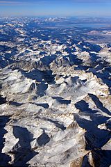
Description: North-northwest view of the Mills Creek cirque (center) in the Sierra National Forest near the midpoint of the Sierra Crest, which extends along the cirque's southeast corner (right) at Mounts Abbot and Mills northward from La Salle Lake (bottom, partially shadowed), the image's centerline is through the south side of the cirque between Mounts Hilgard (left, casting shadow w/ sunlit streak) and Gabb (right of centerline), then north of the cirque along the Sierra Crest's Red and White and Red Slate mountains (right of centerline). The crest extends northwest to Mammoth Crest and Mammoth Mountain and then west of Mono Lake (top, blue) in the north, e.g., across Tioga Pass west of the Wheeler Crest. Between the cirque and Mono Lake is Crowley Lake (white, right of centerline).
Title: Sierra Nevada aerial
Credit: Sierra Nevada (Uploaded by hike395)
Author: Jeffrey Pang from Pittsburgh, PA, USA
Permission: This file is licensed under the Creative Commons Attribution 2.0 Generic license. You are free: to share – to copy, distribute and transmit the work to remix – to adapt the work Under the following conditions: attribution – You must attribute the work in the manner specified by the author or licensor (but not in any way that suggests that they endorse you or your use of the work). http://creativecommons.org/licenses/by/2.0 CC BY 2.0 Creative Commons Attribution 2.0 truetrue This image, which was originally posted to Picasa Web Albums, was reviewed on 08:41, 12 February 2010 (UTC) by the administrator or reviewer Dcoetzee, who confirmed that it was available on Picasa Web Albums under the above license on that date.
Usage Terms: Creative Commons Attribution 2.0
License: CC BY 2.0
License Link: http://creativecommons.org/licenses/by/2.0
Attribution Required?: Yes
Image usage
The following 3 pages link to this image:
