
Image: Spuyten Duyvil IRT map
No higher resolution available.
Spuyten_Duyvil_IRT_map.jpg (200 × 272 pixels, file size: 10 KB, MIME type: image/jpeg)
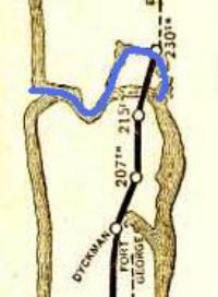
Description: This is a detail from IRT map from 1906. The original path of the Spuyten Duyvil Creek is shown in blue. Notice how Marble Hill is surrounded by a small waterway, which was eventually filled in to physically attach Marble Hill to the Bronx.
Title: Spuyten Duyvil IRT map
Credit: www.nycsubway.org; scanned from the Official Guide of the Railways, Nov. 1906 plus alterations by Beyond My Ken (talk)
Author: Interborough Rapid Transit Company
Usage Terms: Public domain
License: Public domain
Attribution Required?: No
Image usage
The following 2 pages link to this image:

All content from Kiddle encyclopedia articles (including the article images and facts) can be freely used under Attribution-ShareAlike license, unless stated otherwise.