
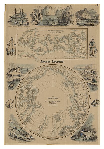
Image: The Arctic Regions, showing the North-West Passage as determined by Cap. R. McClure and other Arctic Voyagers. 1856. CTASC

Description: Two maps of arctic regions published in 1856 on a single sheet as part of The Royal Illustrated Atlas of Modern Geography. The arctic circle is shown in the lower of two maps, while the upper map shows the Parry Islands in what is now the Northwest Territories of Canada. Surrounding these two maps there are illustrations of arctic scenes and people, including Inuit, walruses, polar bears, and the HMS Terror. Bodies of water, islands, and harbours are labelled throughout. The former resting place of the HMS Resolute can be seen in the upper map.
Title: The Arctic Regions, showing the North-West Passage as determined by Cap. R. McClure and other Arctic Voyagers. 1856.
Credit: York University Libraries, Clara Thomas Archives & Special Collections, Historical map collection, HMC0004. http://digital.library.yorku.ca/islandora/object/yul:1153559
Author: Johnson, John Hugh McClure, Robert John Le Mesurier, Sir, 1807-1873
Usage Terms: Public domain
License: Public domain
Attribution Required?: No
Image usage
The following 3 pages link to this image:
