
Image: The North-West Territory shewing British Columbia, Vancouver Island, Red River and Saskatchewan Settlements, for the Canadian Almanac 1870 CTASC
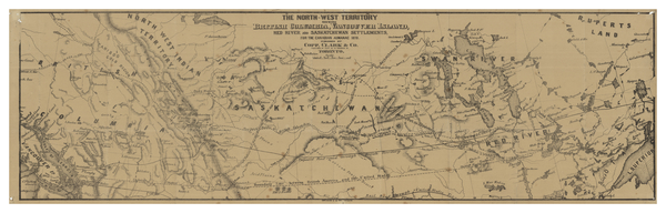
Description: Map showing parts of the Northwest Territories, British Columbia, Saskatchewan, and Manitoba (referred to on the map by its historic name of Red River Settlement), published in 1870. Mountains, bodies of water, cities and towns are named. Railroads and the international border with the United States are outlined. Rupert's Land can be seen in the northeast corner of the map. The Cariboo Gold Region can be seen towards the northwest corner of the map.
Title: The North-West Territory shewing British Columbia, Vancouver Island, Red River and Saskatchewan Settlements, for the Canadian Almanac 1870
Credit: York University Libraries, Clara Thomas Archives & Special Collections, Historical map collection, HMC0007. http://digital.library.yorku.ca/islandora/object/yul:1153571
Author: Copp, Clark & Co.
Usage Terms: Public domain
License: Public domain
Attribution Required?: No
Image usage
The following 3 pages link to this image:
